You are here: Home > Network List > TA - USArray Transportable Network (new EarthScope stations) Stations List
> Station J28A Allard Ranch, Norris, SD, USA > Earthquake Result Viewer
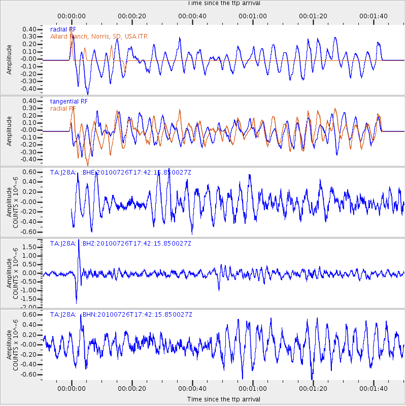
J28A Allard Ranch, Norris, SD, USA - Earthquake Result Viewer
*The percent match for this event was below the threshold and hence no stack was calculated.
| Earthquake location: |
Salta Province, Argentina |
| Earthquake latitude/longitude: |
-24.1/-66.8 |
| Earthquake time(UTC): |
2010/07/26 (207) 17:31:31 GMT |
| Earthquake Depth: |
193 km |
| Earthquake Magnitude: |
5.6 MW, 5.3 MB, 5.5 MW |
| Earthquake Catalog/Contributor: |
WHDF/NEIC |
|
| Network: |
TA USArray Transportable Network (new EarthScope stations) |
| Station: |
J28A Allard Ranch, Norris, SD, USA |
| Lat/Lon: |
43.42 N/101.24 W |
| Elevation: |
835 m |
|
| Distance: |
74.2 deg |
| Az: |
334.668 deg |
| Baz: |
147.53 deg |
| Ray Param: |
$rayparam |
*The percent match for this event was below the threshold and hence was not used in the summary stack. |
|
| Radial Match: |
56.20401 % |
| Radial Bump: |
400 |
| Transverse Match: |
46.8533 % |
| Transverse Bump: |
400 |
| SOD ConfigId: |
319893 |
| Insert Time: |
2011-01-05 12:55:48.036 +0000 |
| GWidth: |
2.5 |
| Max Bumps: |
400 |
| Tol: |
0.001 |
|
Signal To Noise
| Channel | StoN | STA | LTA |
| TA:J28A: :BHZ:20100726T17:42:15.850027Z | 8.631114 | 6.2983344E-7 | 7.297243E-8 |
| TA:J28A: :BHN:20100726T17:42:15.850027Z | 1.6140034 | 2.8486963E-7 | 1.7649877E-7 |
| TA:J28A: :BHE:20100726T17:42:15.850027Z | 1.4899745 | 3.276703E-7 | 2.1991671E-7 |
| Arrivals |
| Ps | |
| PpPs | |
| PsPs/PpSs | |


