You are here: Home > Network List > TA - USArray Transportable Network (new EarthScope stations) Stations List
> Station H28A Mission Ridge, SD, USA > Earthquake Result Viewer
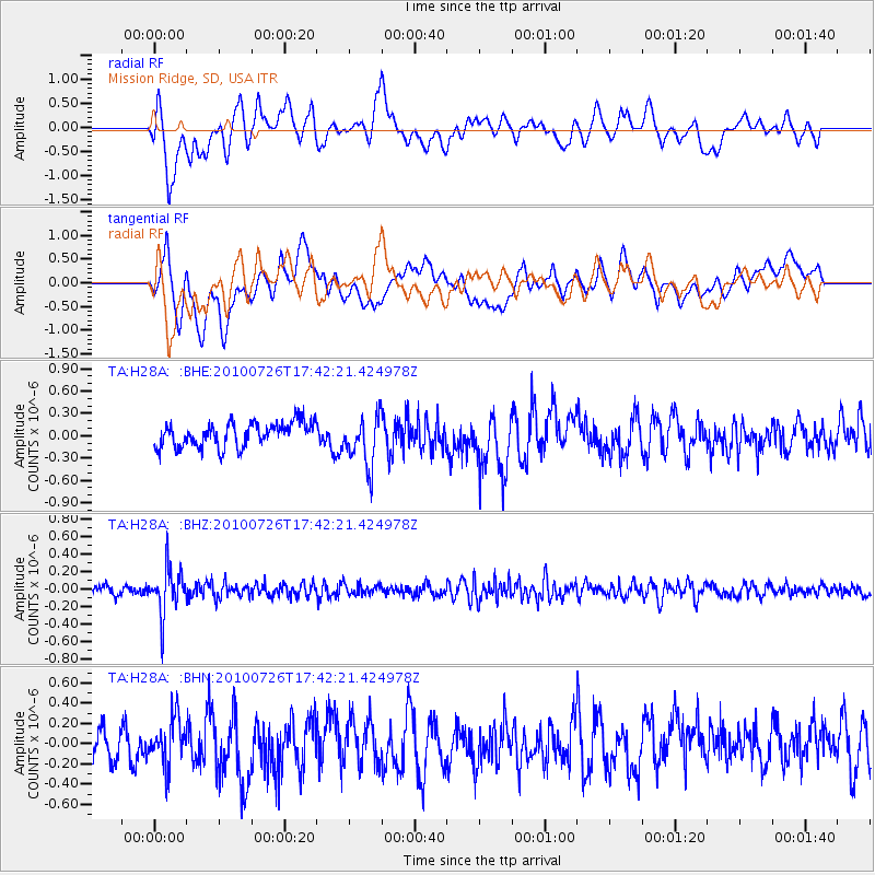
H28A Mission Ridge, SD, USA - Earthquake Result Viewer
*The percent match for this event was below the threshold and hence no stack was calculated.
| Earthquake location: |
Salta Province, Argentina |
| Earthquake latitude/longitude: |
-24.1/-66.8 |
| Earthquake time(UTC): |
2010/07/26 (207) 17:31:31 GMT |
| Earthquake Depth: |
193 km |
| Earthquake Magnitude: |
5.6 MW, 5.3 MB, 5.5 MW |
| Earthquake Catalog/Contributor: |
WHDF/NEIC |
|
| Network: |
TA USArray Transportable Network (new EarthScope stations) |
| Station: |
H28A Mission Ridge, SD, USA |
| Lat/Lon: |
44.68 N/101.02 W |
| Elevation: |
642 m |
|
| Distance: |
75.2 deg |
| Az: |
335.497 deg |
| Baz: |
147.898 deg |
| Ray Param: |
$rayparam |
*The percent match for this event was below the threshold and hence was not used in the summary stack. |
|
| Radial Match: |
56.12293 % |
| Radial Bump: |
400 |
| Transverse Match: |
63.512127 % |
| Transverse Bump: |
400 |
| SOD ConfigId: |
319893 |
| Insert Time: |
2011-01-05 12:56:27.379 +0000 |
| GWidth: |
2.5 |
| Max Bumps: |
400 |
| Tol: |
0.001 |
|
Signal To Noise
| Channel | StoN | STA | LTA |
| TA:H28A: :BHZ:20100726T17:42:21.424978Z | 6.1314464 | 2.6001118E-7 | 4.2406175E-8 |
| TA:H28A: :BHN:20100726T17:42:21.424978Z | 1.2876747 | 2.2653714E-7 | 1.7592731E-7 |
| TA:H28A: :BHE:20100726T17:42:21.424978Z | 2.0832038 | 3.352722E-7 | 1.6094067E-7 |
| Arrivals |
| Ps | |
| PpPs | |
| PsPs/PpSs | |


