You are here: Home > Network List > GE - GEOFON Stations List
> Station SNAA GEOFON/AWI Station Sanae, Antarctica > Earthquake Result Viewer
SNAA GEOFON/AWI Station Sanae, Antarctica - Earthquake Result Viewer
| Earthquake location: |
West Of Macquarie Island |
| Earthquake latitude/longitude: |
-52.0/139.6 |
| Earthquake time(UTC): |
2023/10/11 (284) 20:04:58 GMT |
| Earthquake Depth: |
12 km |
| Earthquake Magnitude: |
6.4 mww |
| Earthquake Catalog/Contributor: |
NEIC PDE/us |
|
| Network: |
GE GEOFON |
| Station: |
SNAA GEOFON/AWI Station Sanae, Antarctica |
| Lat/Lon: |
71.67 S/2.84 W |
| Elevation: |
846 m |
|
| Distance: |
53.8 deg |
| Az: |
193.826 deg |
| Baz: |
152.19 deg |
| Ray Param: |
0.06588207 |
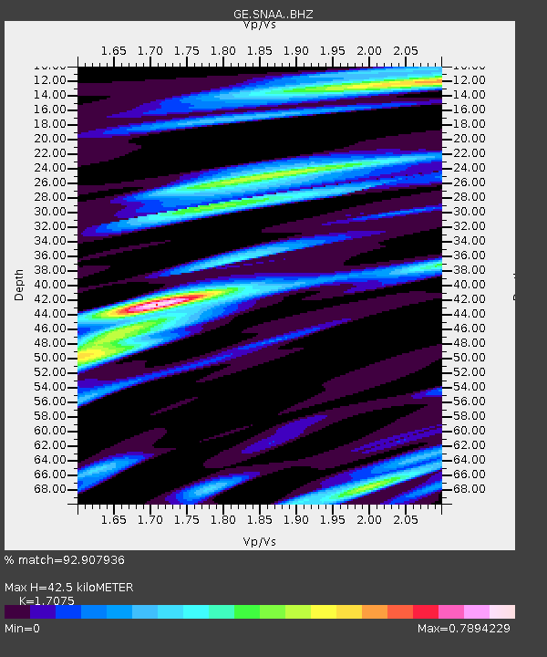
| Estimated Moho Depth: |
42.5 km |
| Estimated Crust Vp/Vs: |
1.71 |
| Assumed Crust Vp: |
6.43 km/s |
| Estimated Crust Vs: |
3.766 km/s |
| Estimated Crust Poisson's Ratio: |
0.24 |
|
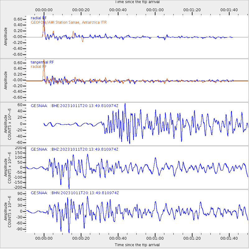
| Radial Match: |
92.907936 % |
| Radial Bump: |
333 |
| Transverse Match: |
84.27614 % |
| Transverse Bump: |
400 |
| SOD ConfigId: |
31937991 |
| Insert Time: |
2023-10-25 20:08:34.711 +0000 |
| GWidth: |
2.5 |
| Max Bumps: |
400 |
| Tol: |
0.001 |
|
Signal To Noise
| Channel | StoN | STA | LTA |
| GE:SNAA: :BHZ:20231011T20:13:49.810974Z | 5.363916 | 3.6965634E-5 | 6.8915383E-6 |
| GE:SNAA: :BHN:20231011T20:13:49.810974Z | 2.0752132 | 1.4299013E-5 | 6.890383E-6 |
| GE:SNAA: :BHE:20231011T20:13:49.810974Z | 4.4804683 | 1.3322797E-5 | 2.9735277E-6 |
| Arrivals |
| Ps | 4.9 SECOND |
| PpPs | 17 SECOND |
| PsPs/PpSs | 22 SECOND |


