You are here: Home > Network List > GS - US Geological Survey Networks Stations List
> Station OK051 E0350 and S34600 Roads, Ralston, OK > Earthquake Result Viewer
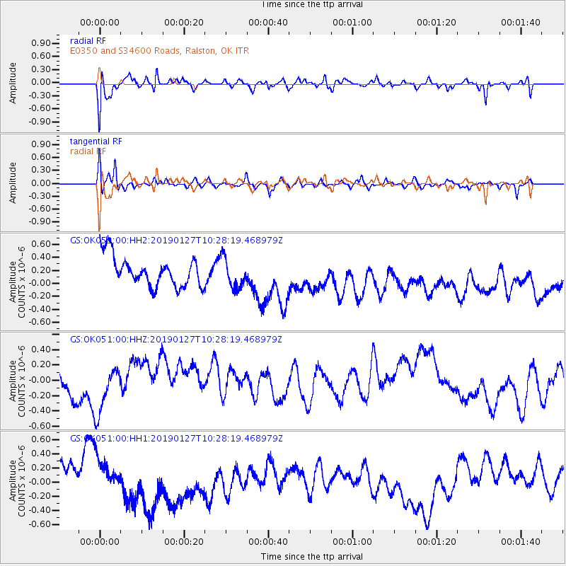
OK051 E0350 and S34600 Roads, Ralston, OK - Earthquake Result Viewer
*The percent match for this event was below the threshold and hence no stack was calculated.
| Earthquake location: |
Fiji Islands Region |
| Earthquake latitude/longitude: |
-20.1/-177.8 |
| Earthquake time(UTC): |
2019/01/27 (027) 10:16:27 GMT |
| Earthquake Depth: |
550 km |
| Earthquake Magnitude: |
5.8 Mww |
| Earthquake Catalog/Contributor: |
NEIC PDE/us |
|
| Network: |
GS US Geological Survey Networks |
| Station: |
OK051 E0350 and S34600 Roads, Ralston, OK |
| Lat/Lon: |
36.51 N/96.84 W |
| Elevation: |
263 m |
|
| Distance: |
94.8 deg |
| Az: |
52.989 deg |
| Baz: |
248.64 deg |
| Ray Param: |
$rayparam |
*The percent match for this event was below the threshold and hence was not used in the summary stack. |
|
| Radial Match: |
73.872154 % |
| Radial Bump: |
400 |
| Transverse Match: |
69.47563 % |
| Transverse Bump: |
400 |
| SOD ConfigId: |
3276131 |
| Insert Time: |
2019-02-10 10:30:35.774 +0000 |
| GWidth: |
2.5 |
| Max Bumps: |
400 |
| Tol: |
0.001 |
|
Signal To Noise
| Channel | StoN | STA | LTA |
| GS:OK051:00:HHZ:20190127T10:28:19.468979Z | 1.2894733 | 2.6065172E-7 | 2.0213812E-7 |
| GS:OK051:00:HH1:20190127T10:28:19.468979Z | 0.6938073 | 1.3501568E-7 | 1.9460111E-7 |
| GS:OK051:00:HH2:20190127T10:28:19.468979Z | 1.0040303 | 2.3093581E-7 | 2.3000881E-7 |
| Arrivals |
| Ps | |
| PpPs | |
| PsPs/PpSs | |


