You are here: Home > Network List > TA - USArray Transportable Network (new EarthScope stations) Stations List
> Station P33A Williams Farm, Concordia, KS, USA > Earthquake Result Viewer
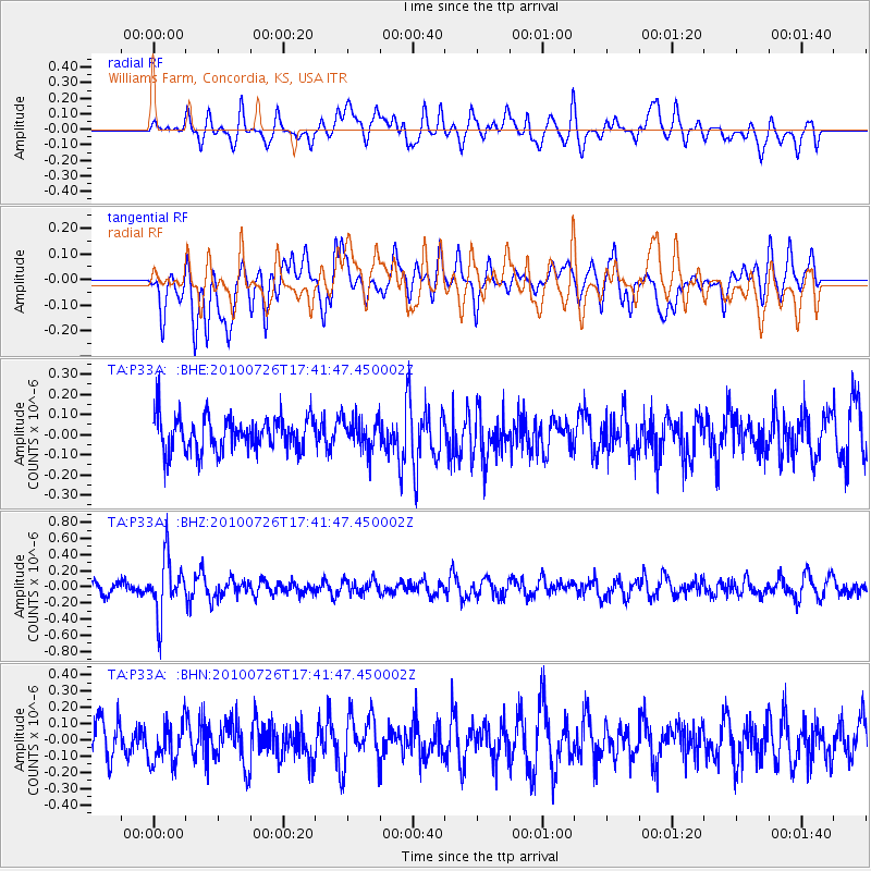
P33A Williams Farm, Concordia, KS, USA - Earthquake Result Viewer
*The percent match for this event was below the threshold and hence no stack was calculated.
| Earthquake location: |
Salta Province, Argentina |
| Earthquake latitude/longitude: |
-24.1/-66.8 |
| Earthquake time(UTC): |
2010/07/26 (207) 17:31:31 GMT |
| Earthquake Depth: |
193 km |
| Earthquake Magnitude: |
5.6 MW, 5.3 MB, 5.5 MW |
| Earthquake Catalog/Contributor: |
WHDF/NEIC |
|
| Network: |
TA USArray Transportable Network (new EarthScope stations) |
| Station: |
P33A Williams Farm, Concordia, KS, USA |
| Lat/Lon: |
39.44 N/97.69 W |
| Elevation: |
488 m |
|
| Distance: |
69.4 deg |
| Az: |
334.888 deg |
| Baz: |
149.936 deg |
| Ray Param: |
$rayparam |
*The percent match for this event was below the threshold and hence was not used in the summary stack. |
|
| Radial Match: |
45.35677 % |
| Radial Bump: |
400 |
| Transverse Match: |
58.500736 % |
| Transverse Bump: |
400 |
| SOD ConfigId: |
319893 |
| Insert Time: |
2011-01-05 13:01:32.240 +0000 |
| GWidth: |
2.5 |
| Max Bumps: |
400 |
| Tol: |
0.001 |
|
Signal To Noise
| Channel | StoN | STA | LTA |
| TA:P33A: :BHZ:20100726T17:41:47.450002Z | 3.313455 | 3.440803E-7 | 1.0384336E-7 |
| TA:P33A: :BHN:20100726T17:41:47.450002Z | 0.8927211 | 1.2933873E-7 | 1.4488145E-7 |
| TA:P33A: :BHE:20100726T17:41:47.450002Z | 0.9116478 | 7.860591E-8 | 8.6223984E-8 |
| Arrivals |
| Ps | |
| PpPs | |
| PsPs/PpSs | |


