You are here: Home > Network List > US - United States National Seismic Network Stations List
> Station EGMT Eagleton, Montana, USA > Earthquake Result Viewer
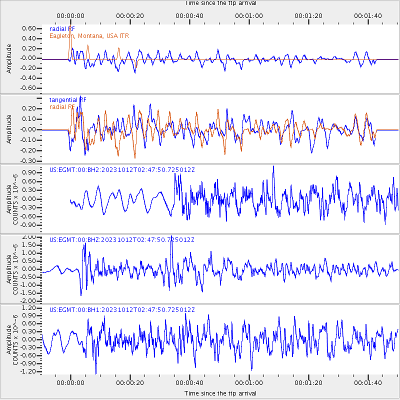
EGMT Eagleton, Montana, USA - Earthquake Result Viewer
*The percent match for this event was below the threshold and hence no stack was calculated.
| Earthquake location: |
Fox Islands, Aleutian Islands |
| Earthquake latitude/longitude: |
52.6/-171.2 |
| Earthquake time(UTC): |
2023/10/12 (285) 02:41:11 GMT |
| Earthquake Depth: |
125 km |
| Earthquake Magnitude: |
5.5 ml |
| Earthquake Catalog/Contributor: |
NEIC PDE/ak |
|
| Network: |
US United States National Seismic Network |
| Station: |
EGMT Eagleton, Montana, USA |
| Lat/Lon: |
48.02 N/109.75 W |
| Elevation: |
1055 m |
|
| Distance: |
38.4 deg |
| Az: |
71.517 deg |
| Baz: |
300.589 deg |
| Ray Param: |
$rayparam |
*The percent match for this event was below the threshold and hence was not used in the summary stack. |
|
| Radial Match: |
51.70315 % |
| Radial Bump: |
400 |
| Transverse Match: |
68.62394 % |
| Transverse Bump: |
400 |
| SOD ConfigId: |
31937991 |
| Insert Time: |
2023-10-26 03:09:36.108 +0000 |
| GWidth: |
2.5 |
| Max Bumps: |
400 |
| Tol: |
0.001 |
|
Signal To Noise
| Channel | StoN | STA | LTA |
| US:EGMT:00:BHZ:20231012T02:47:50.725012Z | 5.2596755 | 6.446067E-7 | 1.2255636E-7 |
| US:EGMT:00:BH1:20231012T02:47:50.725012Z | 0.75804603 | 2.3048327E-7 | 3.0404917E-7 |
| US:EGMT:00:BH2:20231012T02:47:50.725012Z | 1.1919659 | 2.770307E-7 | 2.3241495E-7 |
| Arrivals |
| Ps | |
| PpPs | |
| PsPs/PpSs | |


