You are here: Home > Network List > TA - USArray Transportable Network (new EarthScope stations) Stations List
> Station U37A Salina, OK, USA > Earthquake Result Viewer
U37A Salina, OK, USA - Earthquake Result Viewer
*The percent match for this event was below the threshold and hence no stack was calculated.
| Earthquake location: |
Salta Province, Argentina |
| Earthquake latitude/longitude: |
-24.1/-66.8 |
| Earthquake time(UTC): |
2010/07/26 (207) 17:31:31 GMT |
| Earthquake Depth: |
193 km |
| Earthquake Magnitude: |
5.6 MW, 5.3 MB, 5.5 MW |
| Earthquake Catalog/Contributor: |
WHDF/NEIC |
|
| Network: |
TA USArray Transportable Network (new EarthScope stations) |
| Station: |
U37A Salina, OK, USA |
| Lat/Lon: |
36.41 N/95.12 W |
| Elevation: |
248 m |
|
| Distance: |
65.8 deg |
| Az: |
335.217 deg |
| Baz: |
151.639 deg |
| Ray Param: |
$rayparam |
*The percent match for this event was below the threshold and hence was not used in the summary stack. |
|
| Radial Match: |
59.902157 % |
| Radial Bump: |
400 |
| Transverse Match: |
42.53044 % |
| Transverse Bump: |
400 |
| SOD ConfigId: |
319893 |
| Insert Time: |
2011-01-05 13:11:42.496 +0000 |
| GWidth: |
2.5 |
| Max Bumps: |
400 |
| Tol: |
0.001 |
|
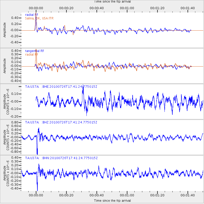
Signal To Noise
| Channel | StoN | STA | LTA |
| TA:U37A: :BHZ:20100726T17:41:24.775015Z | 5.9952116 | 3.076157E-7 | 5.1310234E-8 |
| TA:U37A: :BHN:20100726T17:41:24.775015Z | 2.4871652 | 1.2769952E-7 | 5.1343402E-8 |
| TA:U37A: :BHE:20100726T17:41:24.775015Z | 2.2092338 | 8.9491365E-8 | 4.0507874E-8 |
| Arrivals |
| Ps | |
| PpPs | |
| PsPs/PpSs | |


