You are here: Home > Network List > TA - USArray Transportable Network (new EarthScope stations) Stations List
> Station U36A Oologah, OK, USA > Earthquake Result Viewer
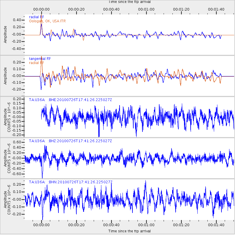
U36A Oologah, OK, USA - Earthquake Result Viewer
*The percent match for this event was below the threshold and hence no stack was calculated.
| Earthquake location: |
Salta Province, Argentina |
| Earthquake latitude/longitude: |
-24.1/-66.8 |
| Earthquake time(UTC): |
2010/07/26 (207) 17:31:31 GMT |
| Earthquake Depth: |
193 km |
| Earthquake Magnitude: |
5.6 MW, 5.3 MB, 5.5 MW |
| Earthquake Catalog/Contributor: |
WHDF/NEIC |
|
| Network: |
TA USArray Transportable Network (new EarthScope stations) |
| Station: |
U36A Oologah, OK, USA |
| Lat/Lon: |
36.39 N/95.73 W |
| Elevation: |
187 m |
|
| Distance: |
66.0 deg |
| Az: |
334.732 deg |
| Baz: |
151.077 deg |
| Ray Param: |
$rayparam |
*The percent match for this event was below the threshold and hence was not used in the summary stack. |
|
| Radial Match: |
58.82354 % |
| Radial Bump: |
400 |
| Transverse Match: |
61.10803 % |
| Transverse Bump: |
400 |
| SOD ConfigId: |
319893 |
| Insert Time: |
2011-01-05 13:11:55.704 +0000 |
| GWidth: |
2.5 |
| Max Bumps: |
400 |
| Tol: |
0.001 |
|
Signal To Noise
| Channel | StoN | STA | LTA |
| TA:U36A: :BHZ:20100726T17:41:26.225027Z | 3.1942844 | 2.8263526E-7 | 8.8481556E-8 |
| TA:U36A: :BHN:20100726T17:41:26.225027Z | 1.7223014 | 9.9000125E-8 | 5.74813E-8 |
| TA:U36A: :BHE:20100726T17:41:26.225027Z | 1.216647 | 6.7953785E-8 | 5.5853327E-8 |
| Arrivals |
| Ps | |
| PpPs | |
| PsPs/PpSs | |


