You are here: Home > Network List > US - United States National Seismic Network Stations List
> Station CBKS Cedar Bluff, Kansas, USA > Earthquake Result Viewer
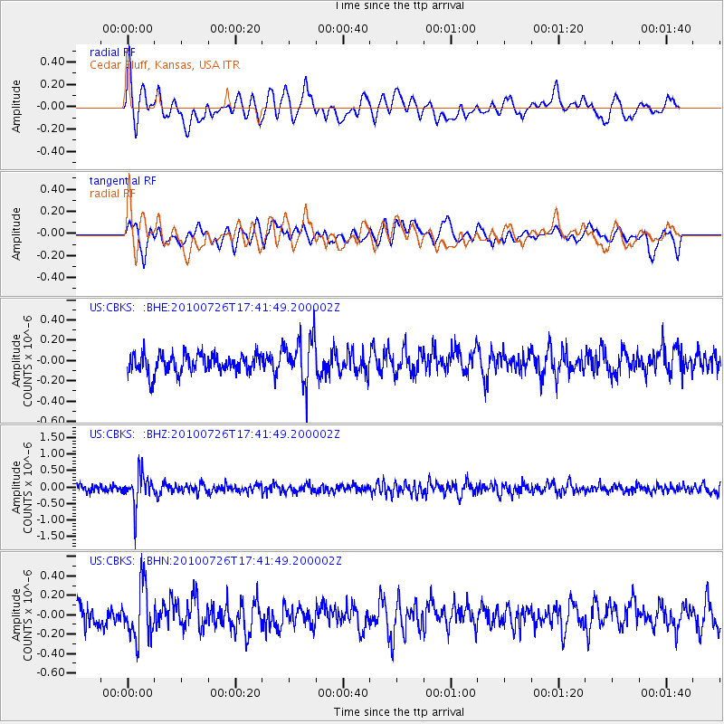
CBKS Cedar Bluff, Kansas, USA - Earthquake Result Viewer
*The percent match for this event was below the threshold and hence no stack was calculated.
| Earthquake location: |
Salta Province, Argentina |
| Earthquake latitude/longitude: |
-24.1/-66.8 |
| Earthquake time(UTC): |
2010/07/26 (207) 17:31:31 GMT |
| Earthquake Depth: |
193 km |
| Earthquake Magnitude: |
5.6 MW, 5.3 MB, 5.5 MW |
| Earthquake Catalog/Contributor: |
WHDF/NEIC |
|
| Network: |
US United States National Seismic Network |
| Station: |
CBKS Cedar Bluff, Kansas, USA |
| Lat/Lon: |
38.81 N/99.74 W |
| Elevation: |
677 m |
|
| Distance: |
69.7 deg |
| Az: |
333.094 deg |
| Baz: |
148.025 deg |
| Ray Param: |
$rayparam |
*The percent match for this event was below the threshold and hence was not used in the summary stack. |
|
| Radial Match: |
64.30484 % |
| Radial Bump: |
400 |
| Transverse Match: |
57.129307 % |
| Transverse Bump: |
400 |
| SOD ConfigId: |
319893 |
| Insert Time: |
2011-01-05 13:13:05.301 +0000 |
| GWidth: |
2.5 |
| Max Bumps: |
400 |
| Tol: |
0.001 |
|
Signal To Noise
| Channel | StoN | STA | LTA |
| US:CBKS: :BHZ:20100726T17:41:49.200002Z | 5.474148 | 4.8791514E-7 | 8.913079E-8 |
| US:CBKS: :BHN:20100726T17:41:49.200002Z | 2.2206233 | 2.7443633E-7 | 1.2358528E-7 |
| US:CBKS: :BHE:20100726T17:41:49.200002Z | 2.457562 | 2.2258094E-7 | 9.056981E-8 |
| Arrivals |
| Ps | |
| PpPs | |
| PsPs/PpSs | |


