You are here: Home > Network List > US - United States National Seismic Network Stations List
> Station LAO LASA Array, Montana, USA > Earthquake Result Viewer
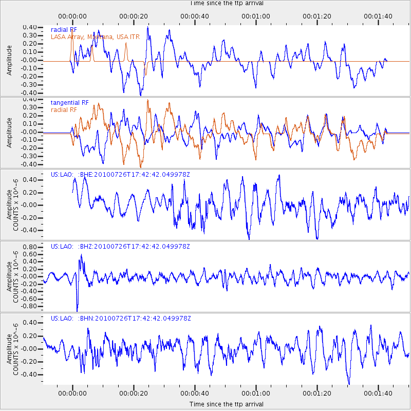
LAO LASA Array, Montana, USA - Earthquake Result Viewer
*The percent match for this event was below the threshold and hence no stack was calculated.
| Earthquake location: |
Salta Province, Argentina |
| Earthquake latitude/longitude: |
-24.1/-66.8 |
| Earthquake time(UTC): |
2010/07/26 (207) 17:31:31 GMT |
| Earthquake Depth: |
193 km |
| Earthquake Magnitude: |
5.6 MW, 5.3 MB, 5.5 MW |
| Earthquake Catalog/Contributor: |
WHDF/NEIC |
|
| Network: |
US United States National Seismic Network |
| Station: |
LAO LASA Array, Montana, USA |
| Lat/Lon: |
46.69 N/106.22 W |
| Elevation: |
902 m |
|
| Distance: |
78.9 deg |
| Az: |
333.561 deg |
| Baz: |
143.752 deg |
| Ray Param: |
$rayparam |
*The percent match for this event was below the threshold and hence was not used in the summary stack. |
|
| Radial Match: |
48.84912 % |
| Radial Bump: |
400 |
| Transverse Match: |
45.677135 % |
| Transverse Bump: |
400 |
| SOD ConfigId: |
319893 |
| Insert Time: |
2011-01-05 13:14:35.710 +0000 |
| GWidth: |
2.5 |
| Max Bumps: |
400 |
| Tol: |
0.001 |
|
Signal To Noise
| Channel | StoN | STA | LTA |
| US:LAO: :BHZ:20100726T17:42:42.049978Z | 4.0072722 | 3.3977776E-7 | 8.479029E-8 |
| US:LAO: :BHN:20100726T17:42:42.049978Z | 1.1912419 | 1.674042E-7 | 1.4052914E-7 |
| US:LAO: :BHE:20100726T17:42:42.049978Z | 1.2143204 | 1.9702495E-7 | 1.622512E-7 |
| Arrivals |
| Ps | |
| PpPs | |
| PsPs/PpSs | |


