You are here: Home > Network List > US - United States National Seismic Network Stations List
> Station EGMT Eagleton, Montana, USA > Earthquake Result Viewer
EGMT Eagleton, Montana, USA - Earthquake Result Viewer
*The percent match for this event was below the threshold and hence no stack was calculated.
| Earthquake location: |
Salta Province, Argentina |
| Earthquake latitude/longitude: |
-24.1/-66.8 |
| Earthquake time(UTC): |
2010/07/26 (207) 17:31:31 GMT |
| Earthquake Depth: |
193 km |
| Earthquake Magnitude: |
5.6 MW, 5.3 MB, 5.5 MW |
| Earthquake Catalog/Contributor: |
WHDF/NEIC |
|
| Network: |
US United States National Seismic Network |
| Station: |
EGMT Eagleton, Montana, USA |
| Lat/Lon: |
48.02 N/109.75 W |
| Elevation: |
1055 m |
|
| Distance: |
81.4 deg |
| Az: |
332.459 deg |
| Baz: |
140.974 deg |
| Ray Param: |
$rayparam |
*The percent match for this event was below the threshold and hence was not used in the summary stack. |
|
| Radial Match: |
20.713324 % |
| Radial Bump: |
400 |
| Transverse Match: |
27.505308 % |
| Transverse Bump: |
400 |
| SOD ConfigId: |
319893 |
| Insert Time: |
2011-01-05 13:14:59.762 +0000 |
| GWidth: |
2.5 |
| Max Bumps: |
400 |
| Tol: |
0.001 |
|
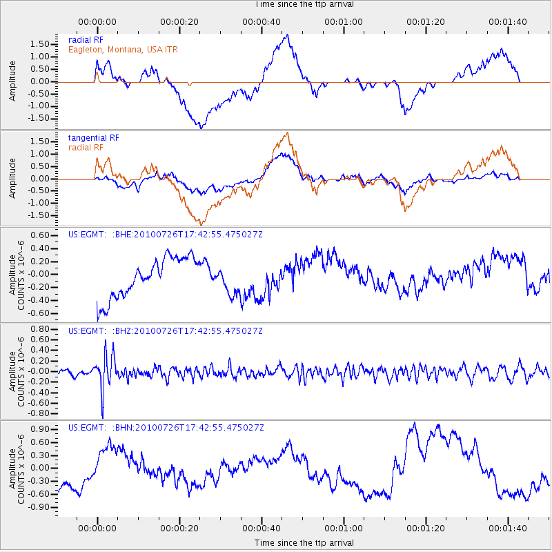
Signal To Noise
| Channel | StoN | STA | LTA |
| US:EGMT: :BHZ:20100726T17:42:55.475027Z | 5.819146 | 3.3183062E-7 | 5.7023936E-8 |
| US:EGMT: :BHN:20100726T17:42:55.475027Z | 0.45328927 | 3.1358348E-7 | 6.9179555E-7 |
| US:EGMT: :BHE:20100726T17:42:55.475027Z | 0.71680516 | 2.1656273E-7 | 3.0212217E-7 |
| Arrivals |
| Ps | |
| PpPs | |
| PsPs/PpSs | |


