You are here: Home > Network List > AV - Alaska Volcano Observatory Stations List
> Station SPU Mount Spurr, Mount Spurr, Alaska > Earthquake Result Viewer
SPU Mount Spurr, Mount Spurr, Alaska - Earthquake Result Viewer
| Earthquake location: |
Northwestern Afghanistan |
| Earthquake latitude/longitude: |
34.6/62.1 |
| Earthquake time(UTC): |
2023/10/15 (288) 03:36:00 GMT |
| Earthquake Depth: |
8.2 km |
| Earthquake Magnitude: |
6.3 Mww |
| Earthquake Catalog/Contributor: |
NEIC PDE/us |
|
| Network: |
AV Alaska Volcano Observatory |
| Station: |
SPU Mount Spurr, Mount Spurr, Alaska |
| Lat/Lon: |
61.18 N/152.06 W |
| Elevation: |
800 m |
|
| Distance: |
80.6 deg |
| Az: |
15.987 deg |
| Baz: |
332.043 deg |
| Ray Param: |
0.048189934 |
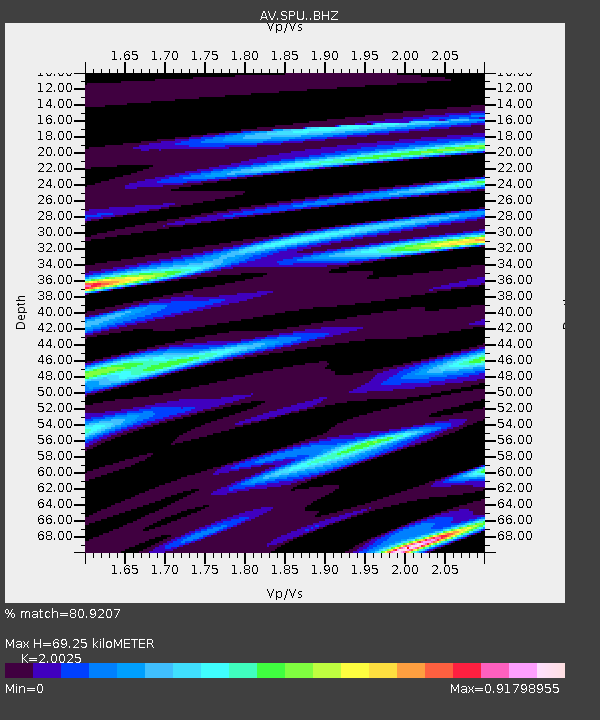
| Estimated Moho Depth: |
69.25 km |
| Estimated Crust Vp/Vs: |
2.00 |
| Assumed Crust Vp: |
6.566 km/s |
| Estimated Crust Vs: |
3.279 km/s |
| Estimated Crust Poisson's Ratio: |
0.33 |
|
| Radial Match: |
80.9207 % |
| Radial Bump: |
400 |
| Transverse Match: |
77.0034 % |
| Transverse Bump: |
400 |
| SOD ConfigId: |
31937991 |
| Insert Time: |
2023-10-29 03:43:49.426 +0000 |
| GWidth: |
2.5 |
| Max Bumps: |
400 |
| Tol: |
0.001 |
|
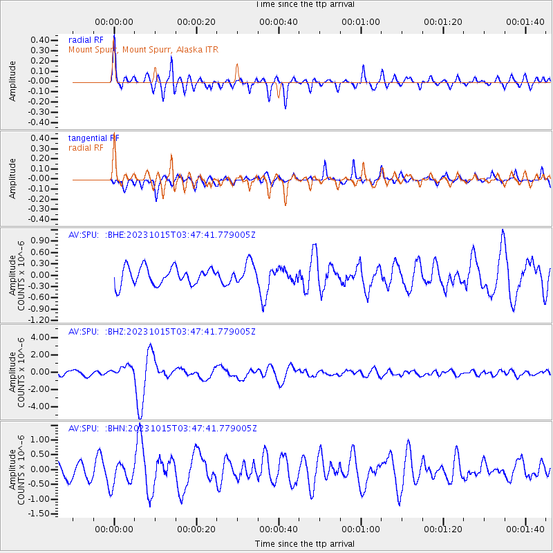
Signal To Noise
| Channel | StoN | STA | LTA |
| AV:SPU: :BHZ:20231015T03:47:41.779005Z | 2.734811 | 6.3178135E-7 | 2.3101462E-7 |
| AV:SPU: :BHN:20231015T03:47:41.779005Z | 1.1094247 | 3.6280778E-7 | 3.2702337E-7 |
| AV:SPU: :BHE:20231015T03:47:41.779005Z | 1.2494377 | 2.8507438E-7 | 2.2816214E-7 |
| Arrivals |
| Ps | 11 SECOND |
| PpPs | 31 SECOND |
| PsPs/PpSs | 42 SECOND |


