You are here: Home > Network List > AZ - ANZA Regional Network Stations List
> Station ASBS AZ.ASBS > Earthquake Result Viewer
ASBS AZ.ASBS - Earthquake Result Viewer

| Earthquake location: |
Kermadec Islands Region |
| Earthquake latitude/longitude: |
-31.2/180.0 |
| Earthquake time(UTC): |
1996/11/05 (310) 09:41:34 GMT |
| Earthquake Depth: |
369 km |
| Earthquake Magnitude: |
5.9 MB, 6.8 UNKNOWN, 6.7 MW |
| Earthquake Catalog/Contributor: |
WHDF/NEIC |
|
| Network: |
AZ ANZA Regional Network |
| Station: |
ASBS AZ.ASBS |
| Lat/Lon: |
33.62 N/116.47 W |
| Elevation: |
1400 m |
|
| Distance: |
88.0 deg |
| Az: |
48.37 deg |
| Baz: |
230.166 deg |
| Ray Param: |
0.041979324 |
| Estimated Moho Depth: |
29.0 km |
| Estimated Crust Vp/Vs: |
1.60 |
| Assumed Crust Vp: |
6.264 km/s |
| Estimated Crust Vs: |
3.915 km/s |
| Estimated Crust Poisson's Ratio: |
0.18 |
|
| Radial Match: |
82.31549 % |
| Radial Bump: |
400 |
| Transverse Match: |
69.73264 % |
| Transverse Bump: |
400 |
| SOD ConfigId: |
6273 |
| Insert Time: |
2010-02-26 18:36:18.866 +0000 |
| GWidth: |
2.5 |
| Max Bumps: |
400 |
| Tol: |
0.001 |
|
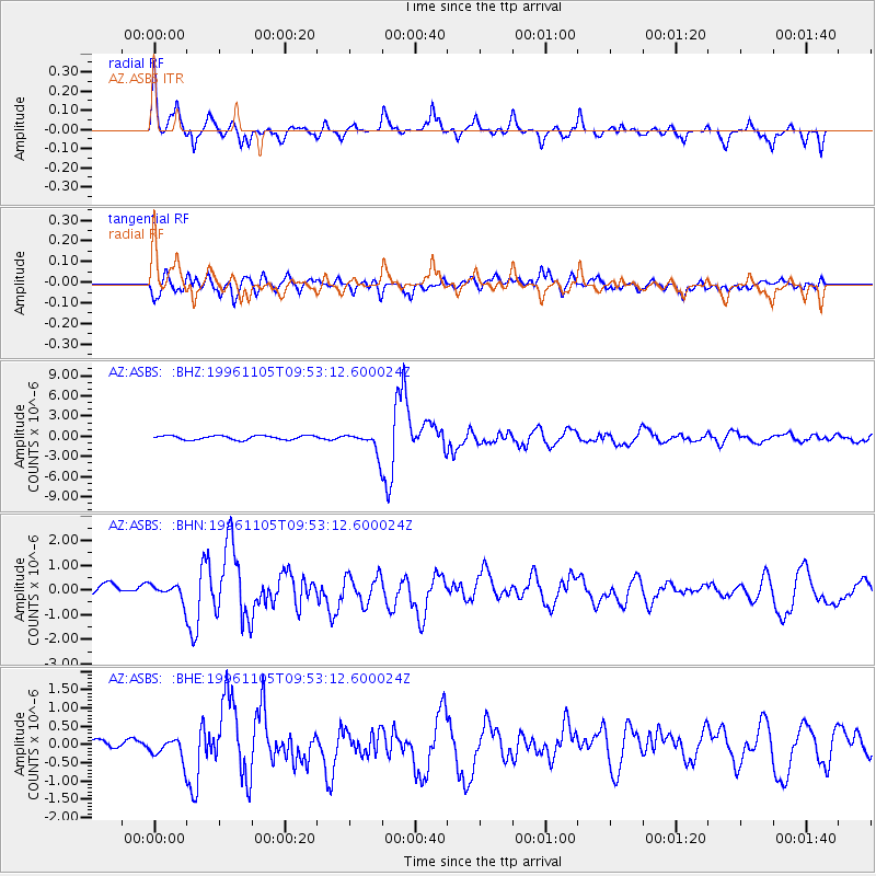
Signal To Noise
| Channel | StoN | STA | LTA |
| AZ:ASBS: :BHN:19961105T09:53:12.600024Z | 0.8302305 | 3.3707872E-7 | 4.060062E-7 |
| AZ:ASBS: :BHE:19961105T09:53:12.600024Z | 1.9773095 | 3.9142535E-7 | 1.9795856E-7 |
| AZ:ASBS: :BHZ:19961105T09:53:12.600024Z | 5.327397 | 1.6145954E-6 | 3.0307396E-7 |
| Arrivals |
| Ps | 2.8 SECOND |
| PpPs | 12 SECOND |
| PsPs/PpSs | 15 SECOND |


