You are here: Home > Network List > G - GEOSCOPE Stations List
> Station TAM Tamanrasset, Algeria > Earthquake Result Viewer
TAM Tamanrasset, Algeria - Earthquake Result Viewer
| Earthquake location: |
Northwestern Afghanistan |
| Earthquake latitude/longitude: |
34.6/62.1 |
| Earthquake time(UTC): |
2023/10/15 (288) 03:36:00 GMT |
| Earthquake Depth: |
8.2 km |
| Earthquake Magnitude: |
6.3 Mww |
| Earthquake Catalog/Contributor: |
NEIC PDE/us |
|
| Network: |
G GEOSCOPE |
| Station: |
TAM Tamanrasset, Algeria |
| Lat/Lon: |
22.79 N/5.53 E |
| Elevation: |
1377 m |
|
| Distance: |
50.4 deg |
| Az: |
272.217 deg |
| Baz: |
63.256 deg |
| Ray Param: |
0.06809828 |
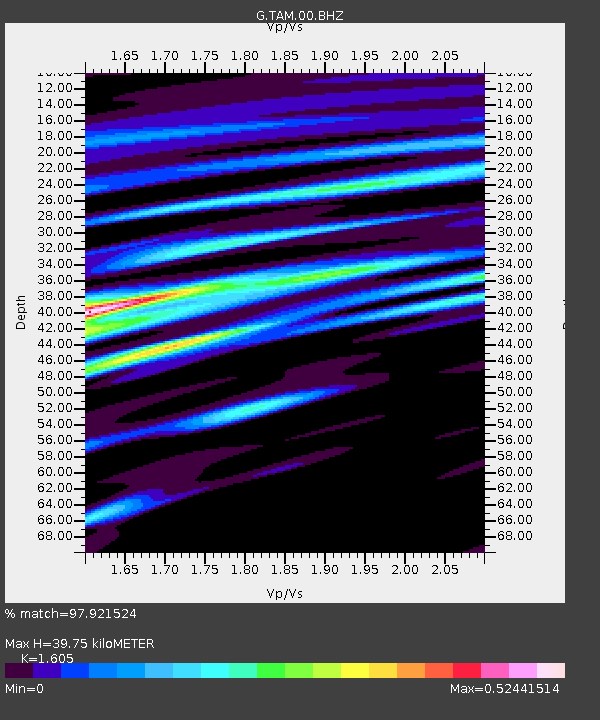
| Estimated Moho Depth: |
39.75 km |
| Estimated Crust Vp/Vs: |
1.61 |
| Assumed Crust Vp: |
6.61 km/s |
| Estimated Crust Vs: |
4.118 km/s |
| Estimated Crust Poisson's Ratio: |
0.18 |
|
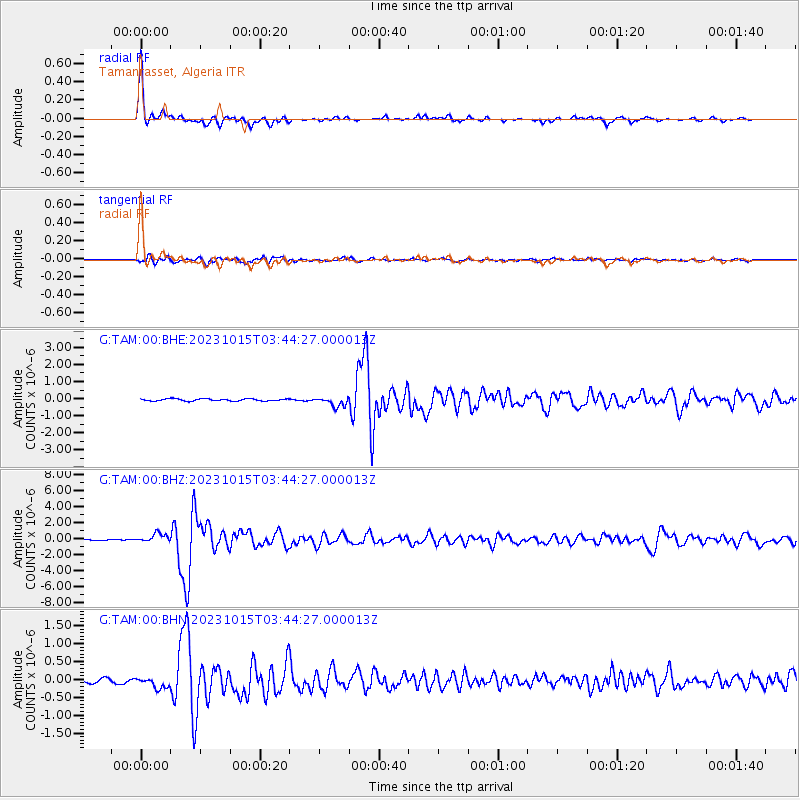
| Radial Match: |
97.921524 % |
| Radial Bump: |
350 |
| Transverse Match: |
85.58833 % |
| Transverse Bump: |
400 |
| SOD ConfigId: |
31937991 |
| Insert Time: |
2023-10-29 03:47:05.351 +0000 |
| GWidth: |
2.5 |
| Max Bumps: |
400 |
| Tol: |
0.001 |
|
Signal To Noise
| Channel | StoN | STA | LTA |
| G:TAM:00:BHZ:20231015T03:44:27.000013Z | 9.1529875 | 5.4489567E-7 | 5.9532002E-8 |
| G:TAM:00:BHN:20231015T03:44:27.000013Z | 3.1110563 | 1.5152895E-7 | 4.870659E-8 |
| G:TAM:00:BHE:20231015T03:44:27.000013Z | 4.4893293 | 2.8086302E-7 | 6.256236E-8 |
| Arrivals |
| Ps | 3.9 SECOND |
| PpPs | 15 SECOND |
| PsPs/PpSs | 19 SECOND |


