You are here: Home > Network List > GS - US Geological Survey Networks Stations List
> Station KAN13 Rinehart Farm > Earthquake Result Viewer
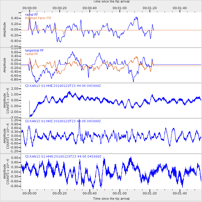
KAN13 Rinehart Farm - Earthquake Result Viewer
*The percent match for this event was below the threshold and hence no stack was calculated.
| Earthquake location: |
Southern Peru |
| Earthquake latitude/longitude: |
-15.5/-72.4 |
| Earthquake time(UTC): |
2019/01/29 (029) 23:35:00 GMT |
| Earthquake Depth: |
109 km |
| Earthquake Magnitude: |
5.5 Mww |
| Earthquake Catalog/Contributor: |
NEIC PDE/us |
|
| Network: |
GS US Geological Survey Networks |
| Station: |
KAN13 Rinehart Farm |
| Lat/Lon: |
37.01 N/97.48 W |
| Elevation: |
340 m |
|
| Distance: |
57.3 deg |
| Az: |
336.242 deg |
| Baz: |
150.973 deg |
| Ray Param: |
$rayparam |
*The percent match for this event was below the threshold and hence was not used in the summary stack. |
|
| Radial Match: |
30.13567 % |
| Radial Bump: |
400 |
| Transverse Match: |
19.773426 % |
| Transverse Bump: |
400 |
| SOD ConfigId: |
3287751 |
| Insert Time: |
2019-02-12 23:46:06.350 +0000 |
| GWidth: |
2.5 |
| Max Bumps: |
400 |
| Tol: |
0.001 |
|
Signal To Noise
| Channel | StoN | STA | LTA |
| GS:KAN13:01:HHZ:20190129T23:44:06.043999Z | 2.662552 | 4.857794E-7 | 1.8244879E-7 |
| GS:KAN13:01:HHN:20190129T23:44:06.043999Z | 1.2795564 | 5.348875E-7 | 4.180257E-7 |
| GS:KAN13:01:HHE:20190129T23:44:06.043999Z | 1.1564295 | 1.1224133E-6 | 9.705851E-7 |
| Arrivals |
| Ps | |
| PpPs | |
| PsPs/PpSs | |


