You are here: Home > Network List > PS - Pacific21 Stations List
> Station JAY Jayapura, Indonesia > Earthquake Result Viewer
JAY Jayapura, Indonesia - Earthquake Result Viewer
| Earthquake location: |
Northwestern Afghanistan |
| Earthquake latitude/longitude: |
34.6/62.1 |
| Earthquake time(UTC): |
2023/10/15 (288) 03:36:00 GMT |
| Earthquake Depth: |
8.2 km |
| Earthquake Magnitude: |
6.3 Mww |
| Earthquake Catalog/Contributor: |
NEIC PDE/us |
|
| Network: |
PS Pacific21 |
| Station: |
JAY Jayapura, Indonesia |
| Lat/Lon: |
2.51 S/140.70 E |
| Elevation: |
439 m |
|
| Distance: |
82.1 deg |
| Az: |
98.542 deg |
| Baz: |
305.277 deg |
| Ray Param: |
0.04712783 |
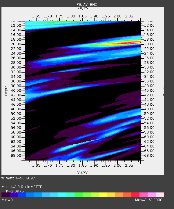
| Estimated Moho Depth: |
19.0 km |
| Estimated Crust Vp/Vs: |
2.10 |
| Assumed Crust Vp: |
6.461 km/s |
| Estimated Crust Vs: |
3.081 km/s |
| Estimated Crust Poisson's Ratio: |
0.35 |
|
| Radial Match: |
90.6697 % |
| Radial Bump: |
374 |
| Transverse Match: |
91.19337 % |
| Transverse Bump: |
400 |
| SOD ConfigId: |
31937991 |
| Insert Time: |
2023-10-29 03:51:28.262 +0000 |
| GWidth: |
2.5 |
| Max Bumps: |
400 |
| Tol: |
0.001 |
|

Signal To Noise
| Channel | StoN | STA | LTA |
| PS:JAY: :BHZ:20231015T03:47:49.860975Z | 7.225322 | 3.991453E-7 | 5.5242563E-8 |
| PS:JAY: :BHN:20231015T03:47:49.860975Z | 1.9717469 | 1.1928871E-7 | 6.0499E-8 |
| PS:JAY: :BHE:20231015T03:47:49.860975Z | 1.7825314 | 1.4245346E-7 | 7.991638E-8 |
| Arrivals |
| Ps | 3.3 SECOND |
| PpPs | 8.9 SECOND |
| PsPs/PpSs | 12 SECOND |


