You are here: Home > Network List > PS - Pacific21 Stations List
> Station PSI Parapat, Indonesia > Earthquake Result Viewer
PSI Parapat, Indonesia - Earthquake Result Viewer
| Earthquake location: |
Northwestern Afghanistan |
| Earthquake latitude/longitude: |
34.6/62.1 |
| Earthquake time(UTC): |
2023/10/15 (288) 03:36:00 GMT |
| Earthquake Depth: |
8.2 km |
| Earthquake Magnitude: |
6.3 Mww |
| Earthquake Catalog/Contributor: |
NEIC PDE/us |
|
| Network: |
PS Pacific21 |
| Station: |
PSI Parapat, Indonesia |
| Lat/Lon: |
2.69 N/98.92 E |
| Elevation: |
987 m |
|
| Distance: |
46.7 deg |
| Az: |
124.594 deg |
| Baz: |
317.183 deg |
| Ray Param: |
0.07047042 |
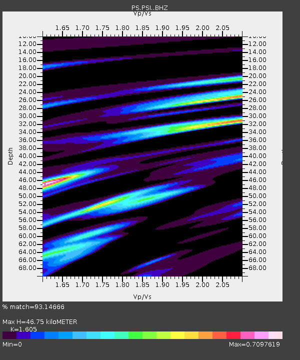
| Estimated Moho Depth: |
46.75 km |
| Estimated Crust Vp/Vs: |
1.61 |
| Assumed Crust Vp: |
6.468 km/s |
| Estimated Crust Vs: |
4.03 km/s |
| Estimated Crust Poisson's Ratio: |
0.18 |
|
| Radial Match: |
93.14666 % |
| Radial Bump: |
387 |
| Transverse Match: |
89.80975 % |
| Transverse Bump: |
400 |
| SOD ConfigId: |
31937991 |
| Insert Time: |
2023-10-29 03:51:35.346 +0000 |
| GWidth: |
2.5 |
| Max Bumps: |
400 |
| Tol: |
0.001 |
|
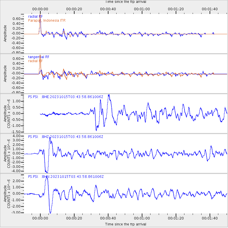
Signal To Noise
| Channel | StoN | STA | LTA |
| PS:PSI: :BHZ:20231015T03:43:58.861006Z | 30.027237 | 2.3979592E-6 | 7.9859475E-8 |
| PS:PSI: :BHN:20231015T03:43:58.861006Z | 21.30416 | 1.3699268E-6 | 6.430326E-8 |
| PS:PSI: :BHE:20231015T03:43:58.861006Z | 12.054199 | 6.7882814E-7 | 5.6314665E-8 |
| Arrivals |
| Ps | 4.7 SECOND |
| PpPs | 18 SECOND |
| PsPs/PpSs | 22 SECOND |


