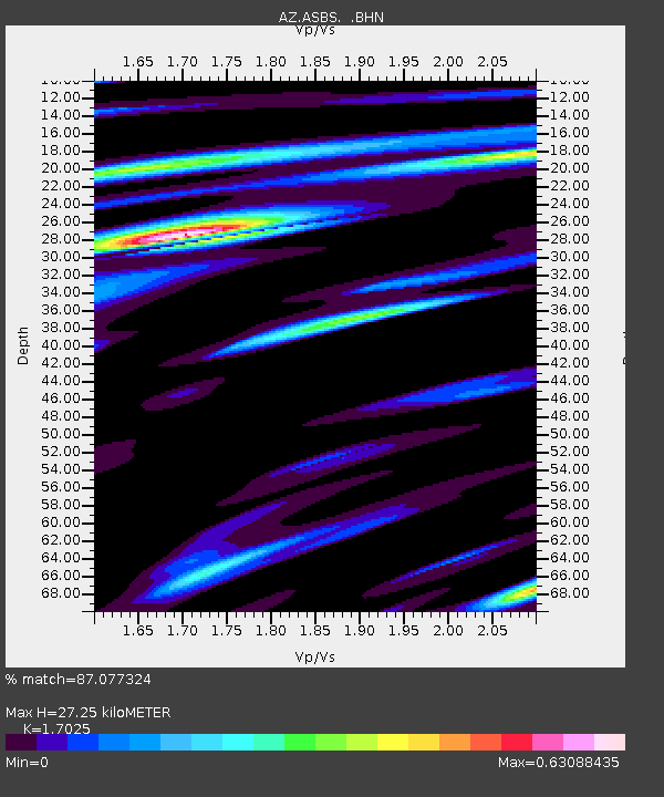
ASBS AZ.ASBS - Earthquake Result Viewer

Earthquake location: Panama-Colombia Border Region
Earthquake latitude/longitude: 7.3/-77.4
Earthquake time(UTC): 1996/11/04 (309) 17:24:57 GMT
Earthquake Depth: 14 km
Earthquake Magnitude: 6.0 MB, 6.0 MS, 6.3 UNKNOWN, 5.3 MD
Earthquake Catalog/Contributor: WHDF/NEIC
Network: AZ ANZA Regional Network
Station: ASBS AZ.ASBS
Lat/Lon: 33.62 N/116.47 W
Elevation: 1400 m
Distance: 44.6 deg
Az: 311.472 deg
Baz: 117.031 deg
Ray Param: 0.071817026
Estimated Moho Depth: 27.25 km
Estimated Crust Vp/Vs: 1.70
Assumed Crust Vp: 6.264 km/s
Estimated Crust Vs: 3.679 km/s
Estimated Crust Poisson's Ratio: 0.24
Radial Match: 87.077324 %
Radial Bump: 324
Transverse Match: 60.599434 %
Transverse Bump: 400
SOD ConfigId: 6273
Insert Time: 2010-02-26 18:36:21.028 +0000
GWidth: 2.5
Max Bumps: 400
Tol: 0.001

Signal To Noise

ChannelStoNSTALTA
AZ:ASBS: :BHN:19961104T17:32:38.025Z1.31497626.6338737E-75.0448625E-7
AZ:ASBS: :BHE:19961104T17:32:38.025Z1.17428955.280952E-74.4971466E-7
AZ:ASBS: :BHZ:19961104T17:32:38.025Z0.448103872.18973E-74.886657E-7
Arrivals
Ps3.3 SECOND
PpPs11 SECOND
PsPs/PpSs14 SECOND