You are here: Home > Network List > CC - Cascade Chain Volcano Monitoring Stations List
> Station TABR Tahoma Bridge > Earthquake Result Viewer
TABR Tahoma Bridge - Earthquake Result Viewer
| Earthquake location: |
Andreanof Islands, Aleutian Is. |
| Earthquake latitude/longitude: |
53.1/-175.5 |
| Earthquake time(UTC): |
2023/10/16 (289) 11:35:30 GMT |
| Earthquake Depth: |
253 km |
| Earthquake Magnitude: |
6.7 Mi |
| Earthquake Catalog/Contributor: |
NEIC PDE/pt |
|
| Network: |
CC Cascade Chain Volcano Monitoring |
| Station: |
TABR Tahoma Bridge |
| Lat/Lon: |
46.80 N/121.85 W |
| Elevation: |
1278 m |
|
| Distance: |
34.4 deg |
| Az: |
78.416 deg |
| Baz: |
300.691 deg |
| Ray Param: |
0.07684247 |
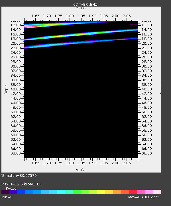
| Estimated Moho Depth: |
12.5 km |
| Estimated Crust Vp/Vs: |
1.60 |
| Assumed Crust Vp: |
6.597 km/s |
| Estimated Crust Vs: |
4.123 km/s |
| Estimated Crust Poisson's Ratio: |
0.18 |
|
| Radial Match: |
80.97579 % |
| Radial Bump: |
400 |
| Transverse Match: |
69.06269 % |
| Transverse Bump: |
400 |
| SOD ConfigId: |
31937991 |
| Insert Time: |
2023-10-30 11:40:44.385 +0000 |
| GWidth: |
2.5 |
| Max Bumps: |
400 |
| Tol: |
0.001 |
|

Signal To Noise
| Channel | StoN | STA | LTA |
| CC:TABR: :BHZ:20231016T11:41:22.880005Z | 2.8563025 | 5.1063046E-7 | 1.7877325E-7 |
| CC:TABR: :BHN:20231016T11:41:22.880005Z | 0.44419098 | 6.181656E-7 | 1.3916662E-6 |
| CC:TABR: :BHE:20231016T11:41:22.880005Z | 0.6153928 | 1.3379338E-6 | 2.1741134E-6 |
| Arrivals |
| Ps | 1.2 SECOND |
| PpPs | 4.5 SECOND |
| PsPs/PpSs | 5.8 SECOND |


