You are here: Home > Network List > CI - Caltech Regional Seismic Network Stations List
> Station BAR Barrett, Tecate, CA, USA > Earthquake Result Viewer
BAR Barrett, Tecate, CA, USA - Earthquake Result Viewer
| Earthquake location: |
Andreanof Islands, Aleutian Is. |
| Earthquake latitude/longitude: |
53.1/-175.5 |
| Earthquake time(UTC): |
2023/10/16 (289) 11:35:30 GMT |
| Earthquake Depth: |
253 km |
| Earthquake Magnitude: |
6.7 Mi |
| Earthquake Catalog/Contributor: |
NEIC PDE/pt |
|
| Network: |
CI Caltech Regional Seismic Network |
| Station: |
BAR Barrett, Tecate, CA, USA |
| Lat/Lon: |
32.68 N/116.67 W |
| Elevation: |
521 m |
|
| Distance: |
46.2 deg |
| Az: |
91.92 deg |
| Baz: |
314.389 deg |
| Ray Param: |
0.069797546 |
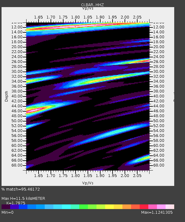
| Estimated Moho Depth: |
11.5 km |
| Estimated Crust Vp/Vs: |
1.80 |
| Assumed Crust Vp: |
6.264 km/s |
| Estimated Crust Vs: |
3.485 km/s |
| Estimated Crust Poisson's Ratio: |
0.28 |
|
| Radial Match: |
95.46172 % |
| Radial Bump: |
400 |
| Transverse Match: |
80.52648 % |
| Transverse Bump: |
400 |
| SOD ConfigId: |
31937991 |
| Insert Time: |
2023-10-30 11:41:01.002 +0000 |
| GWidth: |
2.5 |
| Max Bumps: |
400 |
| Tol: |
0.001 |
|

Signal To Noise
| Channel | StoN | STA | LTA |
| CI:BAR: :HHZ:20231016T11:42:59.328003Z | 1.7297127 | 7.0009605E-7 | 4.0474703E-7 |
| CI:BAR: :HHN:20231016T11:42:59.328003Z | 2.155157 | 7.121848E-7 | 3.304561E-7 |
| CI:BAR: :HHE:20231016T11:42:59.328003Z | 1.4421502 | 5.546117E-7 | 3.8457273E-7 |
| Arrivals |
| Ps | 1.5 SECOND |
| PpPs | 4.9 SECOND |
| PsPs/PpSs | 6.4 SECOND |


