You are here: Home > Network List > GS - US Geological Survey Networks Stations List
> Station OK051 E0350 and S34600 roads, Ralston OK > Earthquake Result Viewer
OK051 E0350 and S34600 roads, Ralston OK - Earthquake Result Viewer
| Earthquake location: |
Andreanof Islands, Aleutian Is. |
| Earthquake latitude/longitude: |
53.1/-175.5 |
| Earthquake time(UTC): |
2023/10/16 (289) 11:35:30 GMT |
| Earthquake Depth: |
253 km |
| Earthquake Magnitude: |
6.7 Mi |
| Earthquake Catalog/Contributor: |
NEIC PDE/pt |
|
| Network: |
GS US Geological Survey Networks |
| Station: |
OK051 E0350 and S34600 roads, Ralston OK |
| Lat/Lon: |
36.50 N/96.84 W |
| Elevation: |
263 m |
|
| Distance: |
55.4 deg |
| Az: |
73.712 deg |
| Baz: |
314.08 deg |
| Ray Param: |
0.06393567 |
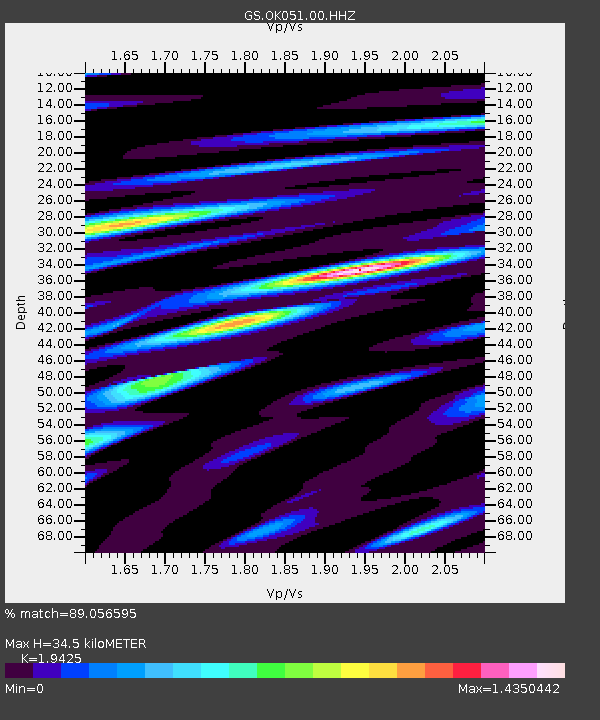
| Estimated Moho Depth: |
34.5 km |
| Estimated Crust Vp/Vs: |
1.94 |
| Assumed Crust Vp: |
6.483 km/s |
| Estimated Crust Vs: |
3.337 km/s |
| Estimated Crust Poisson's Ratio: |
0.32 |
|
| Radial Match: |
89.056595 % |
| Radial Bump: |
341 |
| Transverse Match: |
76.3557 % |
| Transverse Bump: |
400 |
| SOD ConfigId: |
31937991 |
| Insert Time: |
2023-10-30 11:45:50.583 +0000 |
| GWidth: |
2.5 |
| Max Bumps: |
400 |
| Tol: |
0.001 |
|

Signal To Noise
| Channel | StoN | STA | LTA |
| GS:OK051:00:HHZ:20231016T11:44:07.338989Z | 0.7582672 | 1.5321721E-7 | 2.0206231E-7 |
| GS:OK051:00:HH1:20231016T11:44:07.338989Z | 0.99307334 | 1.9912048E-7 | 2.0050933E-7 |
| GS:OK051:00:HH2:20231016T11:44:07.338989Z | 2.4866827 | 5.215523E-7 | 2.0973819E-7 |
| Arrivals |
| Ps | 5.3 SECOND |
| PpPs | 15 SECOND |
| PsPs/PpSs | 20 SECOND |


