You are here: Home > Network List > JP - Japan Meteorological Agency Seismic Network Stations List
> Station JGF Gifu Kurokawa > Earthquake Result Viewer
JGF Gifu Kurokawa - Earthquake Result Viewer
| Earthquake location: |
Andreanof Islands, Aleutian Is. |
| Earthquake latitude/longitude: |
53.1/-175.5 |
| Earthquake time(UTC): |
2023/10/16 (289) 11:35:30 GMT |
| Earthquake Depth: |
253 km |
| Earthquake Magnitude: |
6.7 Mi |
| Earthquake Catalog/Contributor: |
NEIC PDE/pt |
|
| Network: |
JP Japan Meteorological Agency Seismic Network |
| Station: |
JGF Gifu Kurokawa |
| Lat/Lon: |
35.60 N/137.35 E |
| Elevation: |
580 m |
|
| Distance: |
37.2 deg |
| Az: |
261.184 deg |
| Baz: |
46.989 deg |
| Ray Param: |
0.075296655 |
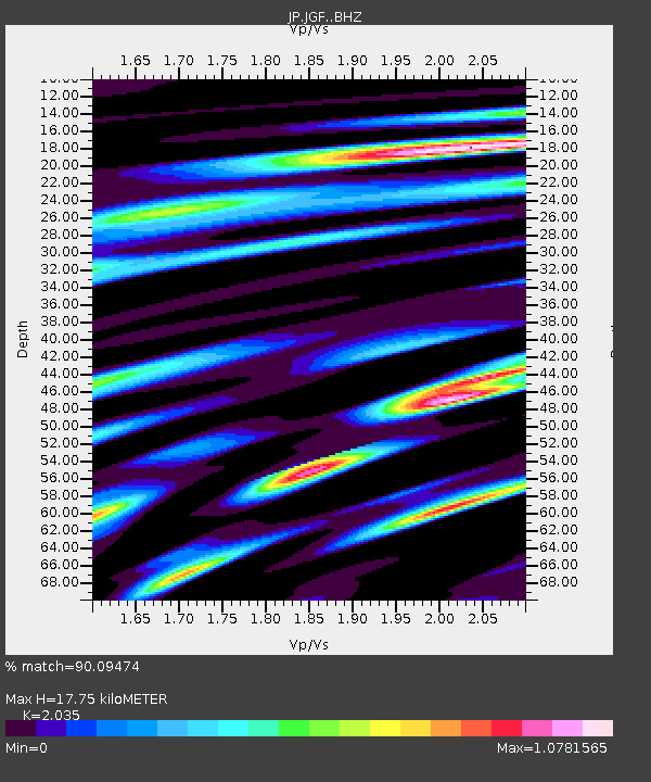
| Estimated Moho Depth: |
17.75 km |
| Estimated Crust Vp/Vs: |
2.04 |
| Assumed Crust Vp: |
6.461 km/s |
| Estimated Crust Vs: |
3.175 km/s |
| Estimated Crust Poisson's Ratio: |
0.34 |
|
| Radial Match: |
90.09474 % |
| Radial Bump: |
400 |
| Transverse Match: |
86.084816 % |
| Transverse Bump: |
400 |
| SOD ConfigId: |
31937991 |
| Insert Time: |
2023-10-30 11:47:14.936 +0000 |
| GWidth: |
2.5 |
| Max Bumps: |
400 |
| Tol: |
0.001 |
|

Signal To Noise
| Channel | StoN | STA | LTA |
| JP:JGF: :BHZ:20231016T11:41:46.649994Z | 48.492756 | 1.5209037E-5 | 3.1363524E-7 |
| JP:JGF: :BHN:20231016T11:41:46.649994Z | 16.766699 | 4.486913E-6 | 2.676086E-7 |
| JP:JGF: :BHE:20231016T11:41:46.649994Z | 21.47899 | 5.057057E-6 | 2.3544203E-7 |
| Arrivals |
| Ps | 3.0 SECOND |
| PpPs | 7.8 SECOND |
| PsPs/PpSs | 11 SECOND |


