You are here: Home > Network List > JP - Japan Meteorological Agency Seismic Network Stations List
> Station JTU Tsushima Kamiagata > Earthquake Result Viewer
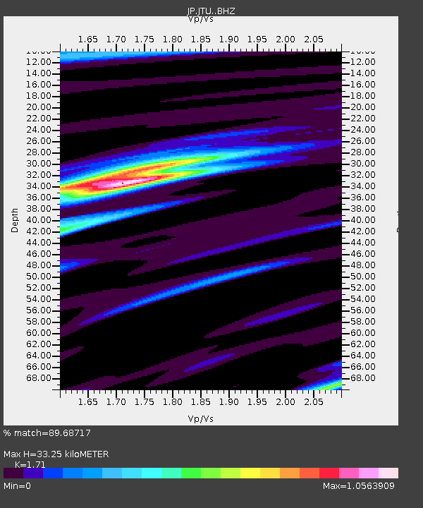
JTU Tsushima Kamiagata - Earthquake Result Viewer
| Earthquake location: |
Andreanof Islands, Aleutian Is. |
| Earthquake latitude/longitude: |
53.1/-175.5 |
| Earthquake time(UTC): |
2023/10/16 (289) 11:35:30 GMT |
| Earthquake Depth: |
253 km |
| Earthquake Magnitude: |
6.7 Mi |
| Earthquake Catalog/Contributor: |
NEIC PDE/pt |
|
| Network: |
JP Japan Meteorological Agency Seismic Network |
| Station: |
JTU Tsushima Kamiagata |
| Lat/Lon: |
34.53 N/129.40 E |
| Elevation: |
70 m |
|
| Distance: |
42.7 deg |
| Az: |
266.908 deg |
| Baz: |
46.827 deg |
| Ray Param: |
0.07200267 |
| Estimated Moho Depth: |
33.25 km |
| Estimated Crust Vp/Vs: |
1.71 |
| Assumed Crust Vp: |
6.472 km/s |
| Estimated Crust Vs: |
3.785 km/s |
| Estimated Crust Poisson's Ratio: |
0.24 |
|
| Radial Match: |
89.68717 % |
| Radial Bump: |
378 |
| Transverse Match: |
73.331474 % |
| Transverse Bump: |
400 |
| SOD ConfigId: |
31937991 |
| Insert Time: |
2023-10-30 11:47:30.246 +0000 |
| GWidth: |
2.5 |
| Max Bumps: |
400 |
| Tol: |
0.001 |
|

Signal To Noise
| Channel | StoN | STA | LTA |
| JP:JTU: :BHZ:20231016T11:42:31.649994Z | 9.182253 | 4.3991695E-6 | 4.790948E-7 |
| JP:JTU: :BHN:20231016T11:42:31.649994Z | 2.9868898 | 1.4866316E-6 | 4.9771893E-7 |
| JP:JTU: :BHE:20231016T11:42:31.649994Z | 6.4651275 | 2.427635E-6 | 3.7549685E-7 |
| Arrivals |
| Ps | 3.9 SECOND |
| PpPs | 13 SECOND |
| PsPs/PpSs | 17 SECOND |


