You are here: Home > Network List > TA - USArray Transportable Network (new EarthScope stations) Stations List
> Station M26A McRoberts Ranch, Bridgeport, NE, USA > Earthquake Result Viewer
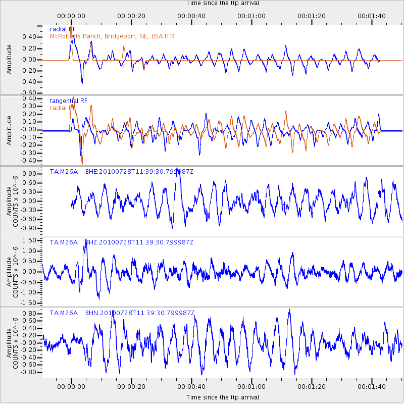
M26A McRoberts Ranch, Bridgeport, NE, USA - Earthquake Result Viewer
*The percent match for this event was below the threshold and hence no stack was calculated.
| Earthquake location: |
Fox Islands, Aleutian Islands |
| Earthquake latitude/longitude: |
52.7/-169.4 |
| Earthquake time(UTC): |
2010/07/28 (209) 11:31:46 GMT |
| Earthquake Depth: |
10 km |
| Earthquake Magnitude: |
5.6 MW, 5.2 MS, 5.2 MB, 5.1 ML |
| Earthquake Catalog/Contributor: |
WHDF/NEIC |
|
| Network: |
TA USArray Transportable Network (new EarthScope stations) |
| Station: |
M26A McRoberts Ranch, Bridgeport, NE, USA |
| Lat/Lon: |
41.47 N/103.14 W |
| Elevation: |
1348 m |
|
| Distance: |
45.0 deg |
| Az: |
76.763 deg |
| Baz: |
307.924 deg |
| Ray Param: |
$rayparam |
*The percent match for this event was below the threshold and hence was not used in the summary stack. |
|
| Radial Match: |
54.986652 % |
| Radial Bump: |
334 |
| Transverse Match: |
66.62847 % |
| Transverse Bump: |
328 |
| SOD ConfigId: |
319893 |
| Insert Time: |
2011-01-05 13:32:37.633 +0000 |
| GWidth: |
2.5 |
| Max Bumps: |
400 |
| Tol: |
0.001 |
|
Signal To Noise
| Channel | StoN | STA | LTA |
| TA:M26A: :BHZ:20100728T11:39:30.799987Z | 3.8977973 | 6.198408E-7 | 1.5902336E-7 |
| TA:M26A: :BHN:20100728T11:39:30.799987Z | 1.2243187 | 1.6563901E-7 | 1.3529075E-7 |
| TA:M26A: :BHE:20100728T11:39:30.799987Z | 1.7252103 | 4.3071174E-7 | 2.4965752E-7 |
| Arrivals |
| Ps | |
| PpPs | |
| PsPs/PpSs | |


