You are here: Home > Network List > TA - USArray Transportable Network (new EarthScope stations) Stations List
> Station 431A Sonora, TX, USA > Earthquake Result Viewer
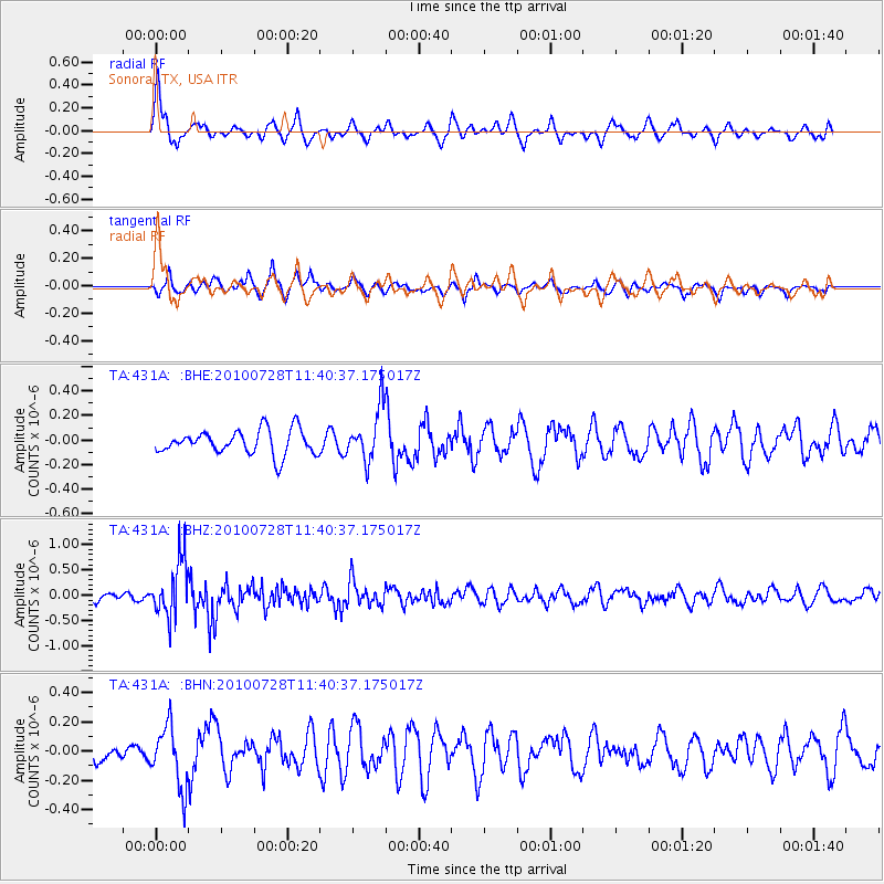
431A Sonora, TX, USA - Earthquake Result Viewer
*The percent match for this event was below the threshold and hence no stack was calculated.
| Earthquake location: |
Fox Islands, Aleutian Islands |
| Earthquake latitude/longitude: |
52.7/-169.4 |
| Earthquake time(UTC): |
2010/07/28 (209) 11:31:46 GMT |
| Earthquake Depth: |
10 km |
| Earthquake Magnitude: |
5.6 MW, 5.2 MS, 5.2 MB, 5.1 ML |
| Earthquake Catalog/Contributor: |
WHDF/NEIC |
|
| Network: |
TA USArray Transportable Network (new EarthScope stations) |
| Station: |
431A Sonora, TX, USA |
| Lat/Lon: |
30.68 N/100.61 W |
| Elevation: |
700 m |
|
| Distance: |
53.7 deg |
| Az: |
85.577 deg |
| Baz: |
315.185 deg |
| Ray Param: |
$rayparam |
*The percent match for this event was below the threshold and hence was not used in the summary stack. |
|
| Radial Match: |
64.94195 % |
| Radial Bump: |
333 |
| Transverse Match: |
64.734375 % |
| Transverse Bump: |
364 |
| SOD ConfigId: |
319893 |
| Insert Time: |
2011-01-05 13:34:57.636 +0000 |
| GWidth: |
2.5 |
| Max Bumps: |
400 |
| Tol: |
0.001 |
|
Signal To Noise
| Channel | StoN | STA | LTA |
| TA:431A: :BHZ:20100728T11:40:37.175017Z | 8.382483 | 5.556985E-7 | 6.629283E-8 |
| TA:431A: :BHN:20100728T11:40:37.175017Z | 2.903317 | 2.0889567E-7 | 7.1950694E-8 |
| TA:431A: :BHE:20100728T11:40:37.175017Z | 2.1399179 | 2.1419035E-7 | 1.0009279E-7 |
| Arrivals |
| Ps | |
| PpPs | |
| PsPs/PpSs | |


