You are here: Home > Network List > CC - Cascade Chain Volcano Monitoring Stations List
> Station ELBE Elbe Fire Station > Earthquake Result Viewer
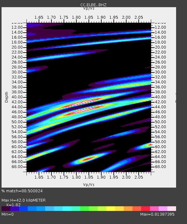
ELBE Elbe Fire Station - Earthquake Result Viewer
| Earthquake location: |
Andreanof Islands, Aleutian Is. |
| Earthquake latitude/longitude: |
52.4/-176.9 |
| Earthquake time(UTC): |
2023/10/16 (289) 11:35:31 GMT |
| Earthquake Depth: |
187 km |
| Earthquake Magnitude: |
6.4 Mww |
| Earthquake Catalog/Contributor: |
NEIC PDE/us |
|
| Network: |
CC Cascade Chain Volcano Monitoring |
| Station: |
ELBE Elbe Fire Station |
| Lat/Lon: |
46.77 N/122.19 W |
| Elevation: |
386 m |
|
| Distance: |
35.1 deg |
| Az: |
76.938 deg |
| Baz: |
299.842 deg |
| Ray Param: |
0.07673045 |
| Estimated Moho Depth: |
42.0 km |
| Estimated Crust Vp/Vs: |
1.82 |
| Assumed Crust Vp: |
6.566 km/s |
| Estimated Crust Vs: |
3.608 km/s |
| Estimated Crust Poisson's Ratio: |
0.28 |
|
| Radial Match: |
88.500824 % |
| Radial Bump: |
400 |
| Transverse Match: |
83.5334 % |
| Transverse Bump: |
400 |
| SOD ConfigId: |
31937991 |
| Insert Time: |
2023-10-30 12:08:43.298 +0000 |
| GWidth: |
2.5 |
| Max Bumps: |
400 |
| Tol: |
0.001 |
|

Signal To Noise
| Channel | StoN | STA | LTA |
| CC:ELBE: :BHZ:20231016T11:41:37.020006Z | 45.51199 | 1.214534E-5 | 2.6686024E-7 |
| CC:ELBE: :BHN:20231016T11:41:37.020006Z | 9.161793 | 2.8370816E-6 | 3.0966447E-7 |
| CC:ELBE: :BHE:20231016T11:41:37.020006Z | 23.682487 | 5.9575973E-6 | 2.515613E-7 |
| Arrivals |
| Ps | 5.7 SECOND |
| PpPs | 17 SECOND |
| PsPs/PpSs | 22 SECOND |


