You are here: Home > Network List > CI - Caltech Regional Seismic Network Stations List
> Station MPP McPhearson Peak > Earthquake Result Viewer
MPP McPhearson Peak - Earthquake Result Viewer

| Earthquake location: |
Andreanof Islands, Aleutian Is. |
| Earthquake latitude/longitude: |
52.4/-176.9 |
| Earthquake time(UTC): |
2023/10/16 (289) 11:35:31 GMT |
| Earthquake Depth: |
187 km |
| Earthquake Magnitude: |
6.4 Mww |
| Earthquake Catalog/Contributor: |
NEIC PDE/us |
|
| Network: |
CI Caltech Regional Seismic Network |
| Station: |
MPP McPhearson Peak |
| Lat/Lon: |
34.89 N/119.81 W |
| Elevation: |
1739 m |
|
| Distance: |
43.6 deg |
| Az: |
90.43 deg |
| Baz: |
311.878 deg |
| Ray Param: |
0.071735755 |
| Estimated Moho Depth: |
20.75 km |
| Estimated Crust Vp/Vs: |
2.10 |
| Assumed Crust Vp: |
6.1 km/s |
| Estimated Crust Vs: |
2.908 km/s |
| Estimated Crust Poisson's Ratio: |
0.35 |
|
| Radial Match: |
88.1255 % |
| Radial Bump: |
400 |
| Transverse Match: |
77.85306 % |
| Transverse Bump: |
400 |
| SOD ConfigId: |
31937991 |
| Insert Time: |
2023-10-30 12:10:05.614 +0000 |
| GWidth: |
2.5 |
| Max Bumps: |
400 |
| Tol: |
0.001 |
|
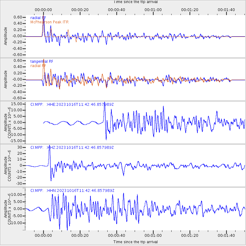
Signal To Noise
| Channel | StoN | STA | LTA |
| CI:MPP: :HHZ:20231016T11:42:46.857989Z | 14.506068 | 1.2596732E-5 | 8.683767E-7 |
| CI:MPP: :HHN:20231016T11:42:46.857989Z | 4.0733757 | 3.5880003E-6 | 8.808419E-7 |
| CI:MPP: :HHE:20231016T11:42:46.857989Z | 6.1303053 | 6.1778555E-6 | 1.0077566E-6 |
| Arrivals |
| Ps | 3.9 SECOND |
| PpPs | 10 SECOND |
| PsPs/PpSs | 14 SECOND |


