You are here: Home > Network List > AZ - ANZA Regional Network Stations List
> Station ASBS AZ.ASBS > Earthquake Result Viewer
ASBS AZ.ASBS - Earthquake Result Viewer
| Earthquake location: |
South Of Fiji Islands |
| Earthquake latitude/longitude: |
-26.8/-177.2 |
| Earthquake time(UTC): |
1996/07/23 (205) 03:32:12 GMT |
| Earthquake Depth: |
33 km |
| Earthquake Magnitude: |
5.8 MB, 6.4 MS, 6.5 UNKNOWN, 6.5 MW |
| Earthquake Catalog/Contributor: |
WHDF/NEIC |
|
| Network: |
AZ ANZA Regional Network |
| Station: |
ASBS AZ.ASBS |
| Lat/Lon: |
33.62 N/116.47 W |
| Elevation: |
1400 m |
|
| Distance: |
83.2 deg |
| Az: |
47.141 deg |
| Baz: |
231.768 deg |
| Ray Param: |
0.046297412 |
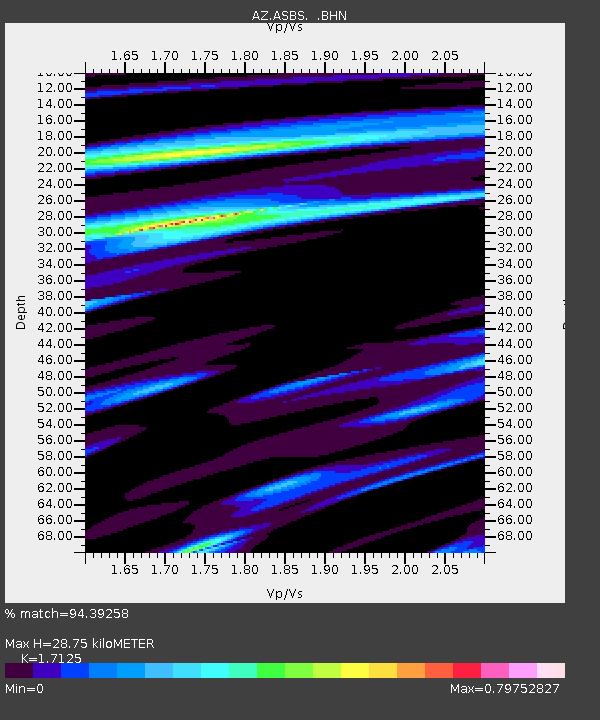
| Estimated Moho Depth: |
28.75 km |
| Estimated Crust Vp/Vs: |
1.71 |
| Assumed Crust Vp: |
6.264 km/s |
| Estimated Crust Vs: |
3.658 km/s |
| Estimated Crust Poisson's Ratio: |
0.24 |
|
| Radial Match: |
94.39258 % |
| Radial Bump: |
400 |
| Transverse Match: |
92.22596 % |
| Transverse Bump: |
400 |
| SOD ConfigId: |
6273 |
| Insert Time: |
2010-02-26 18:36:41.448 +0000 |
| GWidth: |
2.5 |
| Max Bumps: |
400 |
| Tol: |
0.001 |
|

Signal To Noise
| Channel | StoN | STA | LTA |
| AZ:ASBS: :BHN:19960723T03:44:04.448999Z | 1.2124168 | 9.407234E-8 | 7.7590755E-8 |
| AZ:ASBS: :BHE:19960723T03:44:04.448999Z | 1.9837631 | 1.3300311E-7 | 6.704587E-8 |
| AZ:ASBS: :BHZ:19960723T03:44:04.448999Z | 2.5129442 | 3.4527565E-7 | 1.3739884E-7 |
| Arrivals |
| Ps | 3.4 SECOND |
| PpPs | 12 SECOND |
| PsPs/PpSs | 15 SECOND |


