You are here: Home > Network List > CI - Caltech Regional Seismic Network Stations List
> Station TIN Tinemaha, Big Pine, CA, USA > Earthquake Result Viewer
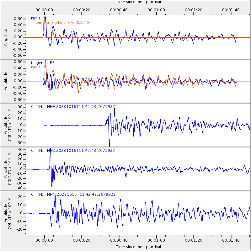
TIN Tinemaha, Big Pine, CA, USA - Earthquake Result Viewer
*The percent match for this event was below the threshold and hence no stack was calculated.
| Earthquake location: |
Andreanof Islands, Aleutian Is. |
| Earthquake latitude/longitude: |
52.4/-176.9 |
| Earthquake time(UTC): |
2023/10/16 (289) 11:35:31 GMT |
| Earthquake Depth: |
187 km |
| Earthquake Magnitude: |
6.4 Mww |
| Earthquake Catalog/Contributor: |
NEIC PDE/us |
|
| Network: |
CI Caltech Regional Seismic Network |
| Station: |
TIN Tinemaha, Big Pine, CA, USA |
| Lat/Lon: |
37.05 N/118.23 W |
| Elevation: |
1197 m |
|
| Distance: |
43.2 deg |
| Az: |
86.829 deg |
| Baz: |
310.186 deg |
| Ray Param: |
$rayparam |
*The percent match for this event was below the threshold and hence was not used in the summary stack. |
|
| Radial Match: |
75.72122 % |
| Radial Bump: |
400 |
| Transverse Match: |
71.56897 % |
| Transverse Bump: |
400 |
| SOD ConfigId: |
31937991 |
| Insert Time: |
2023-10-30 12:10:52.722 +0000 |
| GWidth: |
2.5 |
| Max Bumps: |
400 |
| Tol: |
0.001 |
|
Signal To Noise
| Channel | StoN | STA | LTA |
| CI:TIN: :HHZ:20231016T11:42:43.267992Z | 35.114403 | 1.5850906E-5 | 4.5140754E-7 |
| CI:TIN: :HHN:20231016T11:42:43.267992Z | 10.16619 | 4.7398353E-6 | 4.6623515E-7 |
| CI:TIN: :HHE:20231016T11:42:43.267992Z | 19.16697 | 7.1462296E-6 | 3.7284084E-7 |
| Arrivals |
| Ps | |
| PpPs | |
| PsPs/PpSs | |


