You are here: Home > Network List > CI - Caltech Regional Seismic Network Stations List
> Station VES Vestal, Richgrove, CA, USA > Earthquake Result Viewer
VES Vestal, Richgrove, CA, USA - Earthquake Result Viewer
| Earthquake location: |
Andreanof Islands, Aleutian Is. |
| Earthquake latitude/longitude: |
52.4/-176.9 |
| Earthquake time(UTC): |
2023/10/16 (289) 11:35:31 GMT |
| Earthquake Depth: |
187 km |
| Earthquake Magnitude: |
6.4 Mww |
| Earthquake Catalog/Contributor: |
NEIC PDE/us |
|
| Network: |
CI Caltech Regional Seismic Network |
| Station: |
VES Vestal, Richgrove, CA, USA |
| Lat/Lon: |
35.84 N/119.08 W |
| Elevation: |
154 m |
|
| Distance: |
43.4 deg |
| Az: |
88.823 deg |
| Baz: |
311.132 deg |
| Ray Param: |
0.07185286 |
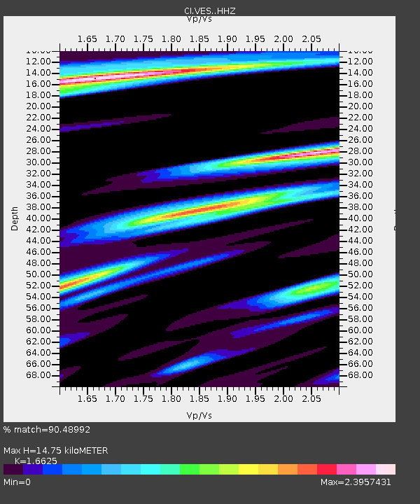
| Estimated Moho Depth: |
14.75 km |
| Estimated Crust Vp/Vs: |
1.66 |
| Assumed Crust Vp: |
6.1 km/s |
| Estimated Crust Vs: |
3.669 km/s |
| Estimated Crust Poisson's Ratio: |
0.22 |
|
| Radial Match: |
90.48992 % |
| Radial Bump: |
374 |
| Transverse Match: |
83.70943 % |
| Transverse Bump: |
372 |
| SOD ConfigId: |
31937991 |
| Insert Time: |
2023-10-30 12:10:57.905 +0000 |
| GWidth: |
2.5 |
| Max Bumps: |
400 |
| Tol: |
0.001 |
|

Signal To Noise
| Channel | StoN | STA | LTA |
| CI:VES: :HHZ:20231016T11:42:45.397997Z | 59.51686 | 2.2750359E-5 | 3.8225062E-7 |
| CI:VES: :HHN:20231016T11:42:45.397997Z | 8.105471 | 6.1560213E-6 | 7.5948964E-7 |
| CI:VES: :HHE:20231016T11:42:45.397997Z | 13.552824 | 7.953227E-6 | 5.868318E-7 |
| Arrivals |
| Ps | 1.7 SECOND |
| PpPs | 6.1 SECOND |
| PsPs/PpSs | 7.8 SECOND |


