You are here: Home > Network List > CN - Canadian National Seismograph Network Stations List
> Station FRB IQALUIT, N.W.T. > Earthquake Result Viewer
FRB IQALUIT, N.W.T. - Earthquake Result Viewer
| Earthquake location: |
Andreanof Islands, Aleutian Is. |
| Earthquake latitude/longitude: |
52.4/-176.9 |
| Earthquake time(UTC): |
2023/10/16 (289) 11:35:31 GMT |
| Earthquake Depth: |
187 km |
| Earthquake Magnitude: |
6.4 Mww |
| Earthquake Catalog/Contributor: |
NEIC PDE/us |
|
| Network: |
CN Canadian National Seismograph Network |
| Station: |
FRB IQALUIT, N.W.T. |
| Lat/Lon: |
63.75 N/68.55 W |
| Elevation: |
18 m |
|
| Distance: |
51.5 deg |
| Az: |
32.661 deg |
| Baz: |
312.033 deg |
| Ray Param: |
0.06670999 |
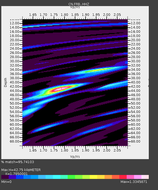
| Estimated Moho Depth: |
42.75 km |
| Estimated Crust Vp/Vs: |
1.79 |
| Assumed Crust Vp: |
6.419 km/s |
| Estimated Crust Vs: |
3.596 km/s |
| Estimated Crust Poisson's Ratio: |
0.27 |
|
| Radial Match: |
95.74103 % |
| Radial Bump: |
359 |
| Transverse Match: |
67.34372 % |
| Transverse Bump: |
400 |
| SOD ConfigId: |
31937991 |
| Insert Time: |
2023-10-30 12:11:56.916 +0000 |
| GWidth: |
2.5 |
| Max Bumps: |
400 |
| Tol: |
0.001 |
|
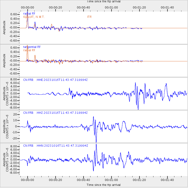
Signal To Noise
| Channel | StoN | STA | LTA |
| CN:FRB: :HHZ:20231016T11:43:47.319994Z | 9.173693 | 3.5616704E-6 | 3.8824828E-7 |
| CN:FRB: :HHN:20231016T11:43:47.319994Z | 5.6711435 | 1.2820647E-6 | 2.2606811E-7 |
| CN:FRB: :HHE:20231016T11:43:47.319994Z | 3.3868947 | 1.2651709E-6 | 3.7354891E-7 |
| Arrivals |
| Ps | 5.5 SECOND |
| PpPs | 18 SECOND |
| PsPs/PpSs | 23 SECOND |


