P28A Satin Francis, KS, USA - Earthquake Result Viewer
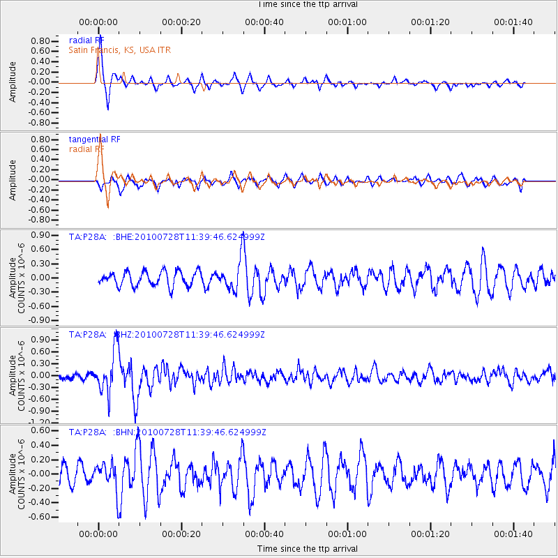
Earthquake location: Fox Islands, Aleutian Islands
Earthquake latitude/longitude: 52.7/-169.4
Earthquake time(UTC): 2010/07/28 (209) 11:31:46 GMT
Earthquake Depth: 10 km
Earthquake Magnitude: 5.6 MW, 5.2 MS, 5.2 MB, 5.1 ML
Earthquake Catalog/Contributor: WHDF/NEIC
Network: TA USArray Transportable Network (new EarthScope stations)
Station: P28A Satin Francis, KS, USA
Lat/Lon: 39.57 N/101.75 W
Elevation: 1105 m
Distance: 47.0 deg
Az: 77.892 deg
Baz: 309.607 deg
Ray Param: 0.070294395
Estimated Moho Depth: 23.25 km
Estimated Crust Vp/Vs: 2.04
Assumed Crust Vp: 6.483 km/s
Estimated Crust Vs: 3.186 km/s
Estimated Crust Poisson's Ratio: 0.34
Radial Match: 84.41998 %
Radial Bump: 375
Transverse Match: 52.616627 %
Transverse Bump: 400
SOD ConfigId: 319893
Insert Time: 2011-01-05 13:39:03.635 +0000
GWidth: 2.5
Max Bumps: 400
Tol: 0.001

Signal To Noise

ChannelStoNSTALTA
TA:P28A: :BHZ:20100728T11:39:46.624999Z6.940435.6120797E-78.0860694E-8
TA:P28A: :BHN:20100728T11:39:46.624999Z1.22527481.9600346E-71.5996693E-7
TA:P28A: :BHE:20100728T11:39:46.624999Z2.21597653.3743552E-71.5227396E-7
Arrivals
Ps3.9 SECOND
PpPs10 SECOND
PsPs/PpSs14 SECOND