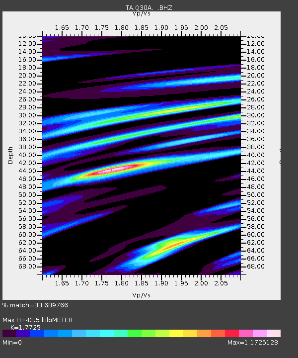
Q30A Quinter, KS, USA - Earthquake Result Viewer
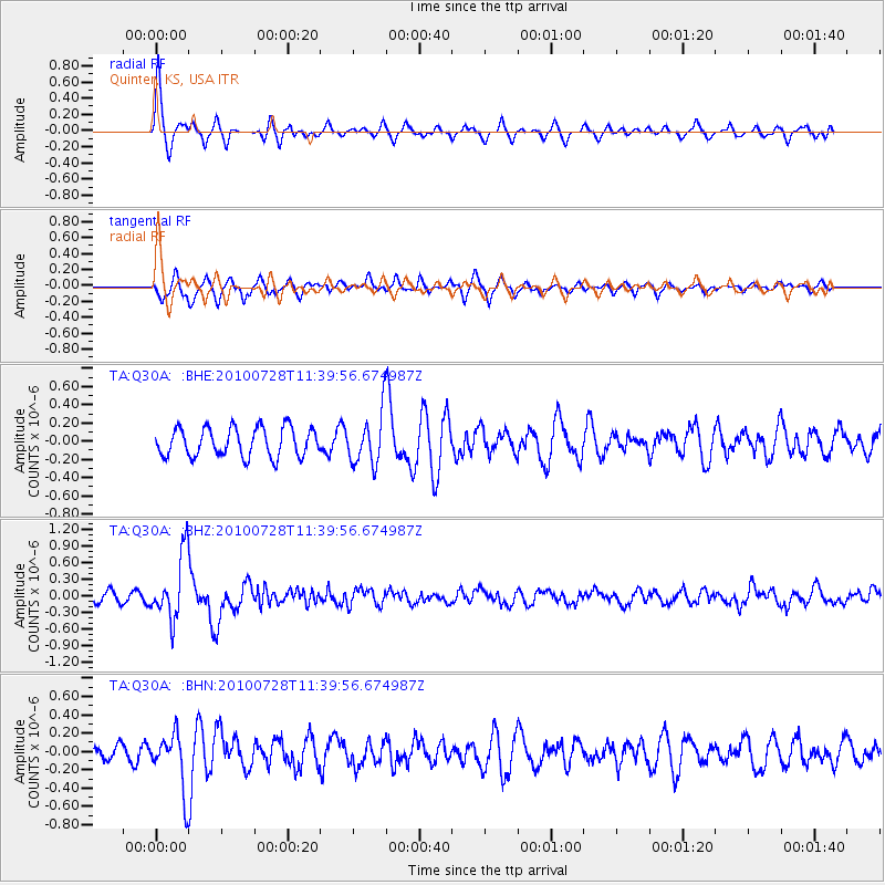
Earthquake location: Fox Islands, Aleutian Islands
Earthquake latitude/longitude: 52.7/-169.4
Earthquake time(UTC): 2010/07/28 (209) 11:31:46 GMT
Earthquake Depth: 10 km
Earthquake Magnitude: 5.6 MW, 5.2 MS, 5.2 MB, 5.1 ML
Earthquake Catalog/Contributor: WHDF/NEIC
Network: TA USArray Transportable Network (new EarthScope stations)
Station: Q30A Quinter, KS, USA
Lat/Lon: 38.98 N/100.22 W
Elevation: 797 m
Distance: 48.3 deg
Az: 77.475 deg
Baz: 310.293 deg
Ray Param: 0.06946457
Estimated Moho Depth: 43.5 km
Estimated Crust Vp/Vs: 1.77
Assumed Crust Vp: 6.483 km/s
Estimated Crust Vs: 3.657 km/s
Estimated Crust Poisson's Ratio: 0.27
Radial Match: 83.689766 %
Radial Bump: 382
Transverse Match: 75.08345 %
Transverse Bump: 400
SOD ConfigId: 319893
Insert Time: 2011-01-05 13:39:28.924 +0000
GWidth: 2.5
Max Bumps: 400
Tol: 0.001

Signal To Noise

ChannelStoNSTALTA
TA:Q30A: :BHZ:20100728T11:39:56.674987Z7.59273865.8314384E-77.6802834E-8
TA:Q30A: :BHN:20100728T11:39:56.674987Z3.69261173.045205E-78.246752E-8
TA:Q30A: :BHE:20100728T11:39:56.674987Z1.81965642.845486E-71.5637492E-7
Arrivals
Ps5.5 SECOND
PpPs17 SECOND
PsPs/PpSs23 SECOND