You are here: Home > Network List > IM - International Miscellaneous Stations Stations List
> Station PD31 PDAR Array, Pinedale, WY, USA > Earthquake Result Viewer
PD31 PDAR Array, Pinedale, WY, USA - Earthquake Result Viewer
| Earthquake location: |
Andreanof Islands, Aleutian Is. |
| Earthquake latitude/longitude: |
52.4/-176.9 |
| Earthquake time(UTC): |
2023/10/16 (289) 11:35:31 GMT |
| Earthquake Depth: |
187 km |
| Earthquake Magnitude: |
6.4 Mww |
| Earthquake Catalog/Contributor: |
NEIC PDE/us |
|
| Network: |
IM International Miscellaneous Stations |
| Station: |
PD31 PDAR Array, Pinedale, WY, USA |
| Lat/Lon: |
42.77 N/109.56 W |
| Elevation: |
2219 m |
|
| Distance: |
44.8 deg |
| Az: |
74.426 deg |
| Baz: |
306.803 deg |
| Ray Param: |
0.070956506 |
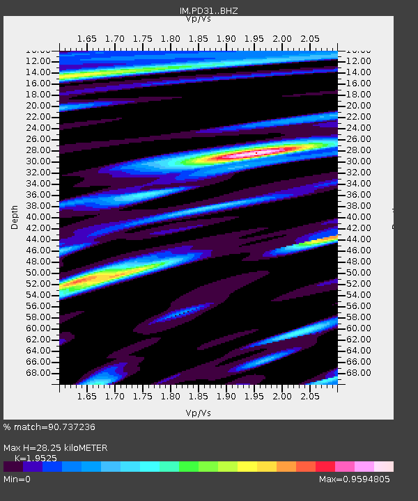
| Estimated Moho Depth: |
28.25 km |
| Estimated Crust Vp/Vs: |
1.95 |
| Assumed Crust Vp: |
6.161 km/s |
| Estimated Crust Vs: |
3.155 km/s |
| Estimated Crust Poisson's Ratio: |
0.32 |
|
| Radial Match: |
90.737236 % |
| Radial Bump: |
367 |
| Transverse Match: |
84.80759 % |
| Transverse Bump: |
400 |
| SOD ConfigId: |
31937991 |
| Insert Time: |
2023-10-30 12:18:23.798 +0000 |
| GWidth: |
2.5 |
| Max Bumps: |
400 |
| Tol: |
0.001 |
|

Signal To Noise
| Channel | StoN | STA | LTA |
| IM:PD31: :BHZ:20231016T11:42:56.650011Z | 38.200287 | 2.3953486E-5 | 6.2704993E-7 |
| IM:PD31: :BHN:20231016T11:42:56.650011Z | 9.3283 | 6.4525134E-6 | 6.917137E-7 |
| IM:PD31: :BHE:20231016T11:42:56.650011Z | 7.2097044 | 5.5948717E-6 | 7.760196E-7 |
| Arrivals |
| Ps | 4.6 SECOND |
| PpPs | 13 SECOND |
| PsPs/PpSs | 17 SECOND |


