You are here: Home > Network List > MB - Montana Regional Seismic Network Stations List
> Station GBMT Granite Butte > Earthquake Result Viewer
GBMT Granite Butte - Earthquake Result Viewer
| Earthquake location: |
Andreanof Islands, Aleutian Is. |
| Earthquake latitude/longitude: |
52.4/-176.9 |
| Earthquake time(UTC): |
2023/10/16 (289) 11:35:31 GMT |
| Earthquake Depth: |
187 km |
| Earthquake Magnitude: |
6.4 Mww |
| Earthquake Catalog/Contributor: |
NEIC PDE/us |
|
| Network: |
MB Montana Regional Seismic Network |
| Station: |
GBMT Granite Butte |
| Lat/Lon: |
46.86 N/112.46 W |
| Elevation: |
2248 m |
|
| Distance: |
40.8 deg |
| Az: |
71.198 deg |
| Baz: |
302.395 deg |
| Ray Param: |
0.073437065 |
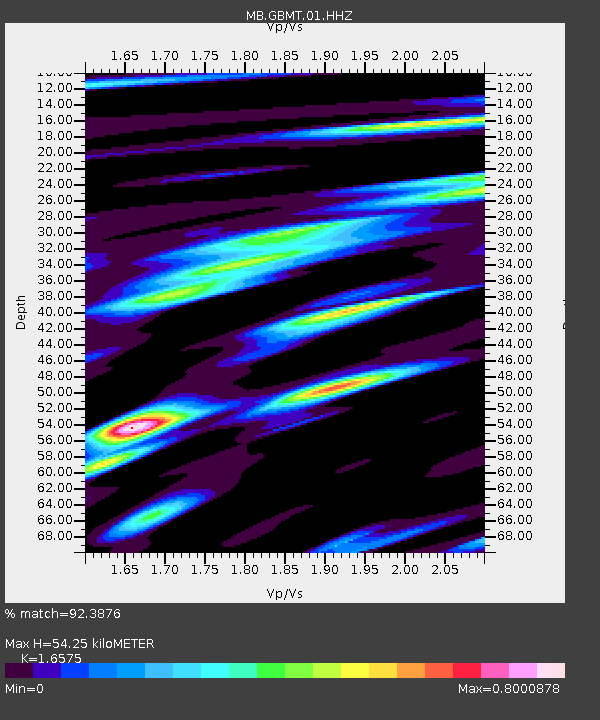
| Estimated Moho Depth: |
54.25 km |
| Estimated Crust Vp/Vs: |
1.66 |
| Assumed Crust Vp: |
6.353 km/s |
| Estimated Crust Vs: |
3.833 km/s |
| Estimated Crust Poisson's Ratio: |
0.21 |
|
| Radial Match: |
92.3876 % |
| Radial Bump: |
277 |
| Transverse Match: |
85.52908 % |
| Transverse Bump: |
400 |
| SOD ConfigId: |
31937991 |
| Insert Time: |
2023-10-30 12:21:09.087 +0000 |
| GWidth: |
2.5 |
| Max Bumps: |
400 |
| Tol: |
0.001 |
|

Signal To Noise
| Channel | StoN | STA | LTA |
| MB:GBMT:01:HHZ:20231016T11:42:24.400011Z | 16.368937 | 5.553581E-6 | 3.392756E-7 |
| MB:GBMT:01:HHN:20231016T11:42:24.400011Z | 6.112002 | 2.449705E-6 | 4.008024E-7 |
| MB:GBMT:01:HHE:20231016T11:42:24.400011Z | 8.993238 | 2.7074868E-6 | 3.0105807E-7 |
| Arrivals |
| Ps | 6.0 SECOND |
| PpPs | 21 SECOND |
| PsPs/PpSs | 27 SECOND |


