You are here: Home > Network List > MB - Montana Regional Seismic Network Stations List
> Station ECMT Emigrant Creek, MT > Earthquake Result Viewer
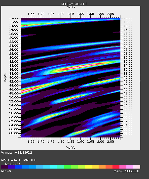
ECMT Emigrant Creek, MT - Earthquake Result Viewer
| Earthquake location: |
Andreanof Islands, Aleutian Is. |
| Earthquake latitude/longitude: |
52.4/-176.9 |
| Earthquake time(UTC): |
2023/10/16 (289) 11:35:31 GMT |
| Earthquake Depth: |
187 km |
| Earthquake Magnitude: |
6.4 Mww |
| Earthquake Catalog/Contributor: |
NEIC PDE/us |
|
| Network: |
MB Montana Regional Seismic Network |
| Station: |
ECMT Emigrant Creek, MT |
| Lat/Lon: |
45.32 N/110.74 W |
| Elevation: |
1567 m |
|
| Distance: |
42.7 deg |
| Az: |
72.14 deg |
| Baz: |
304.332 deg |
| Ray Param: |
0.072309285 |
| Estimated Moho Depth: |
34.0 km |
| Estimated Crust Vp/Vs: |
1.92 |
| Assumed Crust Vp: |
6.35 km/s |
| Estimated Crust Vs: |
3.312 km/s |
| Estimated Crust Poisson's Ratio: |
0.31 |
|
| Radial Match: |
83.43912 % |
| Radial Bump: |
322 |
| Transverse Match: |
80.09288 % |
| Transverse Bump: |
372 |
| SOD ConfigId: |
31937991 |
| Insert Time: |
2023-10-30 12:21:17.303 +0000 |
| GWidth: |
2.5 |
| Max Bumps: |
400 |
| Tol: |
0.001 |
|

Signal To Noise
| Channel | StoN | STA | LTA |
| MB:ECMT:01:HHZ:20231016T11:42:39.319994Z | 41.576824 | 2.0216263E-5 | 4.862387E-7 |
| MB:ECMT:01:HHN:20231016T11:42:39.319994Z | 13.358731 | 1.0573656E-5 | 7.9151647E-7 |
| MB:ECMT:01:HHE:20231016T11:42:39.319994Z | 13.478281 | 8.689353E-6 | 6.4469305E-7 |
| Arrivals |
| Ps | 5.2 SECOND |
| PpPs | 15 SECOND |
| PsPs/PpSs | 20 SECOND |


