You are here: Home > Network List > MB - Montana Regional Seismic Network Stations List
> Station HRY Helena York Bridge > Earthquake Result Viewer
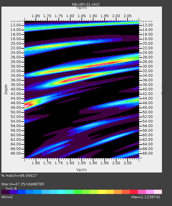
HRY Helena York Bridge - Earthquake Result Viewer
| Earthquake location: |
Andreanof Islands, Aleutian Is. |
| Earthquake latitude/longitude: |
52.4/-176.9 |
| Earthquake time(UTC): |
2023/10/16 (289) 11:35:31 GMT |
| Earthquake Depth: |
187 km |
| Earthquake Magnitude: |
6.4 Mww |
| Earthquake Catalog/Contributor: |
NEIC PDE/us |
|
| Network: |
MB Montana Regional Seismic Network |
| Station: |
HRY Helena York Bridge |
| Lat/Lon: |
46.71 N/111.83 W |
| Elevation: |
1344 m |
|
| Distance: |
41.3 deg |
| Az: |
71.035 deg |
| Baz: |
302.727 deg |
| Ray Param: |
0.07318504 |
| Estimated Moho Depth: |
47.25 km |
| Estimated Crust Vp/Vs: |
1.60 |
| Assumed Crust Vp: |
6.306 km/s |
| Estimated Crust Vs: |
3.941 km/s |
| Estimated Crust Poisson's Ratio: |
0.18 |
|
| Radial Match: |
89.84827 % |
| Radial Bump: |
279 |
| Transverse Match: |
78.95347 % |
| Transverse Bump: |
400 |
| SOD ConfigId: |
31937991 |
| Insert Time: |
2023-10-30 12:21:20.242 +0000 |
| GWidth: |
2.5 |
| Max Bumps: |
400 |
| Tol: |
0.001 |
|

Signal To Noise
| Channel | StoN | STA | LTA |
| MB:HRY:01:HHZ:20231016T11:42:27.999987Z | 23.406717 | 5.4904594E-6 | 2.3456768E-7 |
| MB:HRY:01:HHN:20231016T11:42:27.999987Z | 5.7814403 | 2.196194E-6 | 3.798697E-7 |
| MB:HRY:01:HHE:20231016T11:42:27.999987Z | 8.600535 | 2.7748197E-6 | 3.2263335E-7 |
| Arrivals |
| Ps | 4.8 SECOND |
| PpPs | 18 SECOND |
| PsPs/PpSs | 23 SECOND |


