You are here: Home > Network List > N4 - Central and EAstern US Network Stations List
> Station 352A Blakely, GA, USA > Earthquake Result Viewer
352A Blakely, GA, USA - Earthquake Result Viewer
| Earthquake location: |
Andreanof Islands, Aleutian Is. |
| Earthquake latitude/longitude: |
52.4/-176.9 |
| Earthquake time(UTC): |
2023/10/16 (289) 11:35:31 GMT |
| Earthquake Depth: |
187 km |
| Earthquake Magnitude: |
6.4 Mww |
| Earthquake Catalog/Contributor: |
NEIC PDE/us |
|
| Network: |
N4 Central and EAstern US Network |
| Station: |
352A Blakely, GA, USA |
| Lat/Lon: |
31.48 N/84.93 W |
| Elevation: |
101 m |
|
| Distance: |
66.8 deg |
| Az: |
68.246 deg |
| Baz: |
318.287 deg |
| Ray Param: |
0.056823608 |
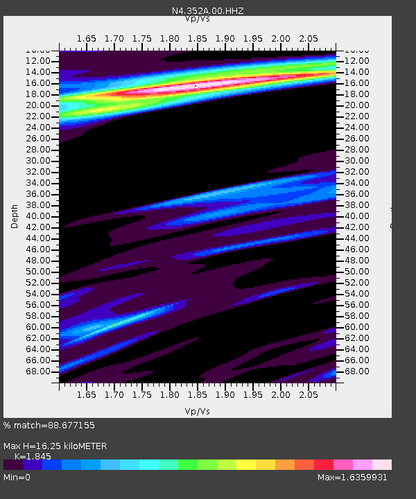
| Estimated Moho Depth: |
16.25 km |
| Estimated Crust Vp/Vs: |
1.85 |
| Assumed Crust Vp: |
6.347 km/s |
| Estimated Crust Vs: |
3.44 km/s |
| Estimated Crust Poisson's Ratio: |
0.29 |
|
| Radial Match: |
88.677155 % |
| Radial Bump: |
400 |
| Transverse Match: |
66.818596 % |
| Transverse Bump: |
400 |
| SOD ConfigId: |
31937991 |
| Insert Time: |
2023-10-30 12:22:12.555 +0000 |
| GWidth: |
2.5 |
| Max Bumps: |
400 |
| Tol: |
0.001 |
|

Signal To Noise
| Channel | StoN | STA | LTA |
| N4:352A:00:HHZ:20231016T11:45:32.439013Z | 18.513092 | 5.0876793E-6 | 2.748152E-7 |
| N4:352A:00:HH1:20231016T11:45:32.439013Z | 3.110871 | 2.1584488E-6 | 6.9384066E-7 |
| N4:352A:00:HH2:20231016T11:45:32.439013Z | 2.4778576 | 1.4484583E-6 | 5.845607E-7 |
| Arrivals |
| Ps | 2.2 SECOND |
| PpPs | 7.0 SECOND |
| PsPs/PpSs | 9.3 SECOND |


