You are here: Home > Network List > N4 - Central and EAstern US Network Stations List
> Station G40A Rib Lake, WI, USA > Earthquake Result Viewer
G40A Rib Lake, WI, USA - Earthquake Result Viewer
| Earthquake location: |
Andreanof Islands, Aleutian Is. |
| Earthquake latitude/longitude: |
52.4/-176.9 |
| Earthquake time(UTC): |
2023/10/16 (289) 11:35:31 GMT |
| Earthquake Depth: |
187 km |
| Earthquake Magnitude: |
6.4 Mww |
| Earthquake Catalog/Contributor: |
NEIC PDE/us |
|
| Network: |
N4 Central and EAstern US Network |
| Station: |
G40A Rib Lake, WI, USA |
| Lat/Lon: |
45.27 N/90.20 W |
| Elevation: |
472 m |
|
| Distance: |
54.2 deg |
| Az: |
60.382 deg |
| Baz: |
311.102 deg |
| Ray Param: |
0.06497424 |
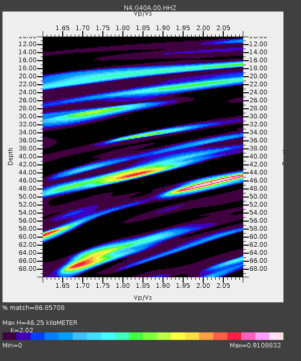
| Estimated Moho Depth: |
46.25 km |
| Estimated Crust Vp/Vs: |
2.02 |
| Assumed Crust Vp: |
6.571 km/s |
| Estimated Crust Vs: |
3.253 km/s |
| Estimated Crust Poisson's Ratio: |
0.34 |
|
| Radial Match: |
86.85708 % |
| Radial Bump: |
286 |
| Transverse Match: |
66.04917 % |
| Transverse Bump: |
400 |
| SOD ConfigId: |
31937991 |
| Insert Time: |
2023-10-30 12:22:35.217 +0000 |
| GWidth: |
2.5 |
| Max Bumps: |
400 |
| Tol: |
0.001 |
|

Signal To Noise
| Channel | StoN | STA | LTA |
| N4:G40A:00:HHZ:20231016T11:44:07.059984Z | 10.418973 | 3.1574891E-6 | 3.0305188E-7 |
| N4:G40A:00:HH1:20231016T11:44:07.059984Z | 8.311872 | 1.7758045E-6 | 2.1364677E-7 |
| N4:G40A:00:HH2:20231016T11:44:07.059984Z | 5.493192 | 1.1717616E-6 | 2.1331161E-7 |
| Arrivals |
| Ps | 7.5 SECOND |
| PpPs | 20 SECOND |
| PsPs/PpSs | 28 SECOND |


