You are here: Home > Network List > N4 - Central and EAstern US Network Stations List
> Station W50A Signal Mountain, TN, USA > Earthquake Result Viewer
W50A Signal Mountain, TN, USA - Earthquake Result Viewer
| Earthquake location: |
Andreanof Islands, Aleutian Is. |
| Earthquake latitude/longitude: |
52.4/-176.9 |
| Earthquake time(UTC): |
2023/10/16 (289) 11:35:31 GMT |
| Earthquake Depth: |
187 km |
| Earthquake Magnitude: |
6.4 Mww |
| Earthquake Catalog/Contributor: |
NEIC PDE/us |
|
| Network: |
N4 Central and EAstern US Network |
| Station: |
W50A Signal Mountain, TN, USA |
| Lat/Lon: |
35.20 N/85.31 W |
| Elevation: |
587 m |
|
| Distance: |
63.9 deg |
| Az: |
65.758 deg |
| Baz: |
317.038 deg |
| Ray Param: |
0.0587344 |
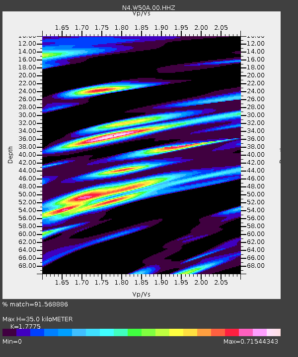
| Estimated Moho Depth: |
35.0 km |
| Estimated Crust Vp/Vs: |
1.78 |
| Assumed Crust Vp: |
6.35 km/s |
| Estimated Crust Vs: |
3.572 km/s |
| Estimated Crust Poisson's Ratio: |
0.27 |
|
| Radial Match: |
91.568886 % |
| Radial Bump: |
400 |
| Transverse Match: |
78.183525 % |
| Transverse Bump: |
400 |
| SOD ConfigId: |
31937991 |
| Insert Time: |
2023-10-30 12:24:49.249 +0000 |
| GWidth: |
2.5 |
| Max Bumps: |
400 |
| Tol: |
0.001 |
|

Signal To Noise
| Channel | StoN | STA | LTA |
| N4:W50A:00:HHZ:20231016T11:45:13.489Z | 16.933851 | 4.4765366E-6 | 2.6435433E-7 |
| N4:W50A:00:HH1:20231016T11:45:13.489Z | 7.7696137 | 1.8134436E-6 | 2.3340203E-7 |
| N4:W50A:00:HH2:20231016T11:45:13.489Z | 10.046398 | 1.6968576E-6 | 1.6890208E-7 |
| Arrivals |
| Ps | 4.5 SECOND |
| PpPs | 15 SECOND |
| PsPs/PpSs | 19 SECOND |


