You are here: Home > Network List > N4 - Central and EAstern US Network Stations List
> Station X48A Hartselle, AL, USA > Earthquake Result Viewer
X48A Hartselle, AL, USA - Earthquake Result Viewer
| Earthquake location: |
Andreanof Islands, Aleutian Is. |
| Earthquake latitude/longitude: |
52.4/-176.9 |
| Earthquake time(UTC): |
2023/10/16 (289) 11:35:31 GMT |
| Earthquake Depth: |
187 km |
| Earthquake Magnitude: |
6.4 Mww |
| Earthquake Catalog/Contributor: |
NEIC PDE/us |
|
| Network: |
N4 Central and EAstern US Network |
| Station: |
X48A Hartselle, AL, USA |
| Lat/Lon: |
34.45 N/87.05 W |
| Elevation: |
180 m |
|
| Distance: |
63.4 deg |
| Az: |
67.49 deg |
| Baz: |
316.821 deg |
| Ray Param: |
0.05900283 |
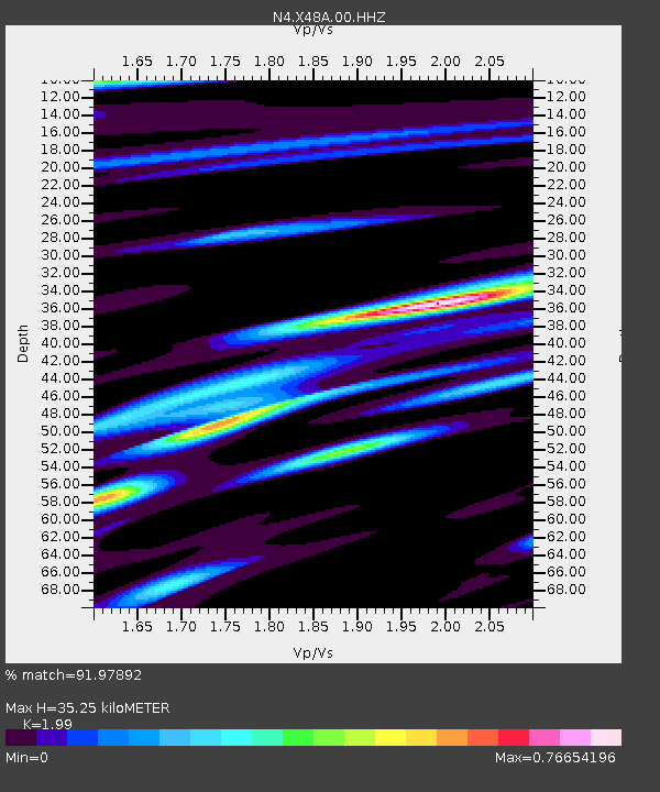
| Estimated Moho Depth: |
35.25 km |
| Estimated Crust Vp/Vs: |
1.99 |
| Assumed Crust Vp: |
6.476 km/s |
| Estimated Crust Vs: |
3.254 km/s |
| Estimated Crust Poisson's Ratio: |
0.33 |
|
| Radial Match: |
91.97892 % |
| Radial Bump: |
377 |
| Transverse Match: |
75.16698 % |
| Transverse Bump: |
400 |
| SOD ConfigId: |
31937991 |
| Insert Time: |
2023-10-30 12:24:55.778 +0000 |
| GWidth: |
2.5 |
| Max Bumps: |
400 |
| Tol: |
0.001 |
|

Signal To Noise
| Channel | StoN | STA | LTA |
| N4:X48A:00:HHZ:20231016T11:45:10.689989Z | 16.321692 | 3.460574E-6 | 2.1202301E-7 |
| N4:X48A:00:HH1:20231016T11:45:10.689989Z | 7.6397905 | 1.1042265E-6 | 1.4453623E-7 |
| N4:X48A:00:HH2:20231016T11:45:10.689989Z | 9.579883 | 1.3896354E-6 | 1.4505765E-7 |
| Arrivals |
| Ps | 5.6 SECOND |
| PpPs | 16 SECOND |
| PsPs/PpSs | 21 SECOND |


