You are here: Home > Network List > NM - Cooperative New Madrid Seismic Network Stations List
> Station PLAL Pickwick Lake, AR > Earthquake Result Viewer
PLAL Pickwick Lake, AR - Earthquake Result Viewer
| Earthquake location: |
Andreanof Islands, Aleutian Is. |
| Earthquake latitude/longitude: |
52.4/-176.9 |
| Earthquake time(UTC): |
2023/10/16 (289) 11:35:31 GMT |
| Earthquake Depth: |
187 km |
| Earthquake Magnitude: |
6.4 Mww |
| Earthquake Catalog/Contributor: |
NEIC PDE/us |
|
| Network: |
NM Cooperative New Madrid Seismic Network |
| Station: |
PLAL Pickwick Lake, AR |
| Lat/Lon: |
34.98 N/88.08 W |
| Elevation: |
165 m |
|
| Distance: |
62.5 deg |
| Az: |
67.773 deg |
| Baz: |
316.366 deg |
| Ray Param: |
0.05963616 |
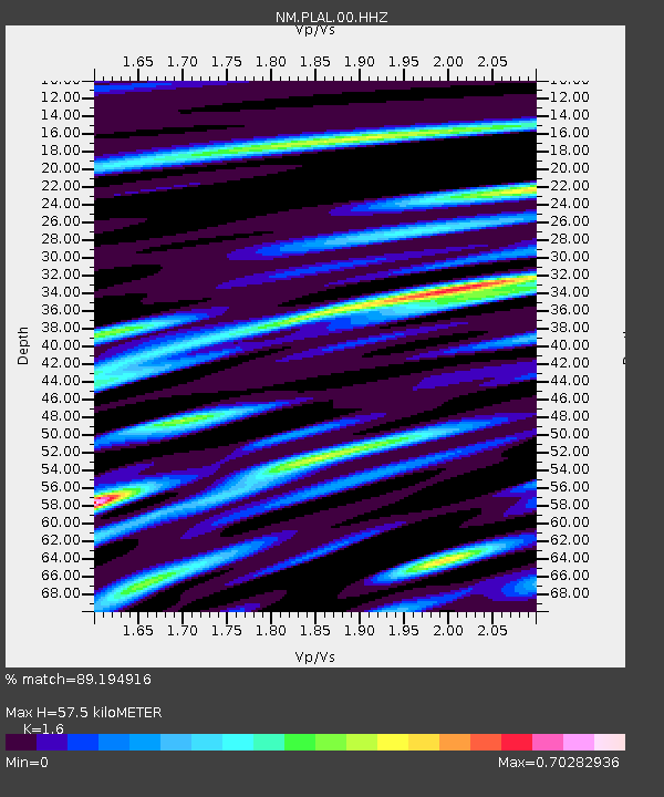
| Estimated Moho Depth: |
57.5 km |
| Estimated Crust Vp/Vs: |
1.60 |
| Assumed Crust Vp: |
6.38 km/s |
| Estimated Crust Vs: |
3.988 km/s |
| Estimated Crust Poisson's Ratio: |
0.18 |
|
| Radial Match: |
89.194916 % |
| Radial Bump: |
350 |
| Transverse Match: |
70.38257 % |
| Transverse Bump: |
400 |
| SOD ConfigId: |
31937991 |
| Insert Time: |
2023-10-30 12:26:00.825 +0000 |
| GWidth: |
2.5 |
| Max Bumps: |
400 |
| Tol: |
0.001 |
|

Signal To Noise
| Channel | StoN | STA | LTA |
| NM:PLAL:00:HHZ:20231016T11:45:04.330004Z | 21.435078 | 3.548919E-6 | 1.6556596E-7 |
| NM:PLAL:00:HHN:20231016T11:45:04.330004Z | 10.6177225 | 1.5811875E-6 | 1.4891965E-7 |
| NM:PLAL:00:HHE:20231016T11:45:04.330004Z | 7.240475 | 1.2081807E-6 | 1.6686484E-7 |
| Arrivals |
| Ps | 5.7 SECOND |
| PpPs | 22 SECOND |
| PsPs/PpSs | 28 SECOND |


