You are here: Home > Network List > O2 - Oklahoma Consolidated Temporary Seismic Networks Stations List
> Station CRES Cresent, Oklahoma, USA > Earthquake Result Viewer
CRES Cresent, Oklahoma, USA - Earthquake Result Viewer
| Earthquake location: |
Andreanof Islands, Aleutian Is. |
| Earthquake latitude/longitude: |
52.4/-176.9 |
| Earthquake time(UTC): |
2023/10/16 (289) 11:35:31 GMT |
| Earthquake Depth: |
187 km |
| Earthquake Magnitude: |
6.4 Mww |
| Earthquake Catalog/Contributor: |
NEIC PDE/us |
|
| Network: |
O2 Oklahoma Consolidated Temporary Seismic Networks |
| Station: |
CRES Cresent, Oklahoma, USA |
| Lat/Lon: |
36.04 N/97.53 W |
| Elevation: |
311 m |
|
| Distance: |
56.3 deg |
| Az: |
73.251 deg |
| Baz: |
313.684 deg |
| Ray Param: |
0.06362505 |
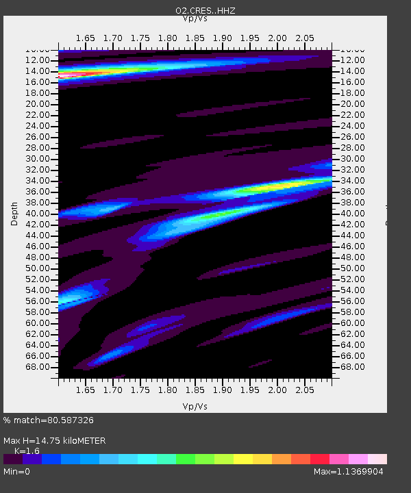
| Estimated Moho Depth: |
14.75 km |
| Estimated Crust Vp/Vs: |
1.60 |
| Assumed Crust Vp: |
6.483 km/s |
| Estimated Crust Vs: |
4.052 km/s |
| Estimated Crust Poisson's Ratio: |
0.18 |
|
| Radial Match: |
80.587326 % |
| Radial Bump: |
379 |
| Transverse Match: |
73.80375 % |
| Transverse Bump: |
400 |
| SOD ConfigId: |
31937991 |
| Insert Time: |
2023-10-30 12:27:12.423 +0000 |
| GWidth: |
2.5 |
| Max Bumps: |
400 |
| Tol: |
0.001 |
|

Signal To Noise
| Channel | StoN | STA | LTA |
| O2:CRES: :HHZ:20231016T11:44:21.980028Z | 22.453737 | 5.4814577E-6 | 2.4412228E-7 |
| O2:CRES: :HHN:20231016T11:44:21.980028Z | 3.551208 | 1.6186846E-6 | 4.5581237E-7 |
| O2:CRES: :HHE:20231016T11:44:21.980028Z | 7.28413 | 2.5649415E-6 | 3.5212733E-7 |
| Arrivals |
| Ps | 1.4 SECOND |
| PpPs | 5.6 SECOND |
| PsPs/PpSs | 7.0 SECOND |


