You are here: Home > Network List > AZ - ANZA Regional Network Stations List
> Station ASBS AZ.ASBS > Earthquake Result Viewer
ASBS AZ.ASBS - Earthquake Result Viewer

| Earthquake location: |
Tonga Islands |
| Earthquake latitude/longitude: |
-15.2/-173.3 |
| Earthquake time(UTC): |
1997/05/27 (147) 08:00:29 GMT |
| Earthquake Depth: |
14 km |
| Earthquake Magnitude: |
5.6 MB, 6.3 MS, 6.4 UNKNOWN, 5.7 ME |
| Earthquake Catalog/Contributor: |
WHDF/NEIC |
|
| Network: |
AZ ANZA Regional Network |
| Station: |
ASBS AZ.ASBS |
| Lat/Lon: |
33.62 N/116.47 W |
| Elevation: |
1400 m |
|
| Distance: |
72.7 deg |
| Az: |
47.025 deg |
| Baz: |
237.832 deg |
| Ray Param: |
0.053452678 |
| Estimated Moho Depth: |
27.25 km |
| Estimated Crust Vp/Vs: |
1.86 |
| Assumed Crust Vp: |
6.264 km/s |
| Estimated Crust Vs: |
3.372 km/s |
| Estimated Crust Poisson's Ratio: |
0.30 |
|
| Radial Match: |
84.5122 % |
| Radial Bump: |
400 |
| Transverse Match: |
66.59578 % |
| Transverse Bump: |
400 |
| SOD ConfigId: |
6273 |
| Insert Time: |
2010-02-26 18:36:59.532 +0000 |
| GWidth: |
2.5 |
| Max Bumps: |
400 |
| Tol: |
0.001 |
|
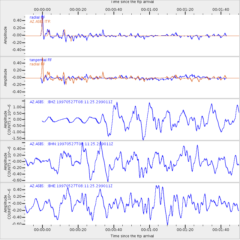
Signal To Noise
| Channel | StoN | STA | LTA |
| AZ:ASBS: :BHN:19970527T08:11:25.299011Z | 1.0187609 | 7.91771E-8 | 7.7719015E-8 |
| AZ:ASBS: :BHE:19970527T08:11:25.299011Z | 0.8586072 | 1.29551E-7 | 1.5088507E-7 |
| AZ:ASBS: :BHZ:19970527T08:11:25.299011Z | 1.689242 | 2.2668998E-7 | 1.3419627E-7 |
| Arrivals |
| Ps | 3.8 SECOND |
| PpPs | 12 SECOND |
| PsPs/PpSs | 16 SECOND |


