You are here: Home > Network List > O2 - Oklahoma Consolidated Temporary Seismic Networks Stations List
> Station PERY Perry, Oklahoma, USA > Earthquake Result Viewer
PERY Perry, Oklahoma, USA - Earthquake Result Viewer
| Earthquake location: |
Andreanof Islands, Aleutian Is. |
| Earthquake latitude/longitude: |
52.4/-176.9 |
| Earthquake time(UTC): |
2023/10/16 (289) 11:35:31 GMT |
| Earthquake Depth: |
187 km |
| Earthquake Magnitude: |
6.4 Mww |
| Earthquake Catalog/Contributor: |
NEIC PDE/us |
|
| Network: |
O2 Oklahoma Consolidated Temporary Seismic Networks |
| Station: |
PERY Perry, Oklahoma, USA |
| Lat/Lon: |
36.26 N/97.24 W |
| Elevation: |
209 m |
|
| Distance: |
56.3 deg |
| Az: |
72.856 deg |
| Baz: |
313.64 deg |
| Ray Param: |
0.06361237 |
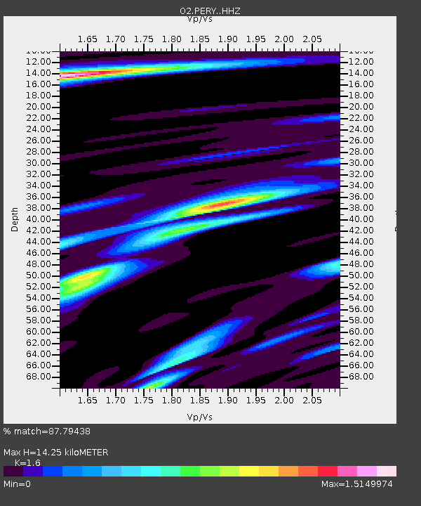
| Estimated Moho Depth: |
14.25 km |
| Estimated Crust Vp/Vs: |
1.60 |
| Assumed Crust Vp: |
6.483 km/s |
| Estimated Crust Vs: |
4.052 km/s |
| Estimated Crust Poisson's Ratio: |
0.18 |
|
| Radial Match: |
87.79438 % |
| Radial Bump: |
346 |
| Transverse Match: |
66.62286 % |
| Transverse Bump: |
400 |
| SOD ConfigId: |
31937991 |
| Insert Time: |
2023-10-30 12:27:40.344 +0000 |
| GWidth: |
2.5 |
| Max Bumps: |
400 |
| Tol: |
0.001 |
|

Signal To Noise
| Channel | StoN | STA | LTA |
| O2:PERY: :HHZ:20231016T11:44:22.140001Z | 20.685133 | 5.1236907E-6 | 2.4769918E-7 |
| O2:PERY: :HHN:20231016T11:44:22.140001Z | 5.8322864 | 1.7137896E-6 | 2.9384523E-7 |
| O2:PERY: :HHE:20231016T11:44:22.140001Z | 7.7097034 | 2.228701E-6 | 2.890774E-7 |
| Arrivals |
| Ps | 1.4 SECOND |
| PpPs | 5.4 SECOND |
| PsPs/PpSs | 6.8 SECOND |


