You are here: Home > Network List > O2 - Oklahoma Consolidated Temporary Seismic Networks Stations List
> Station RNSP Roman Nose State Park, Oklahoma, USA > Earthquake Result Viewer
RNSP Roman Nose State Park, Oklahoma, USA - Earthquake Result Viewer
| Earthquake location: |
Andreanof Islands, Aleutian Is. |
| Earthquake latitude/longitude: |
52.4/-176.9 |
| Earthquake time(UTC): |
2023/10/16 (289) 11:35:31 GMT |
| Earthquake Depth: |
187 km |
| Earthquake Magnitude: |
6.4 Mww |
| Earthquake Catalog/Contributor: |
NEIC PDE/us |
|
| Network: |
O2 Oklahoma Consolidated Temporary Seismic Networks |
| Station: |
RNSP Roman Nose State Park, Oklahoma, USA |
| Lat/Lon: |
35.93 N/98.43 W |
| Elevation: |
453 m |
|
| Distance: |
55.8 deg |
| Az: |
73.942 deg |
| Baz: |
313.548 deg |
| Ray Param: |
0.063913904 |
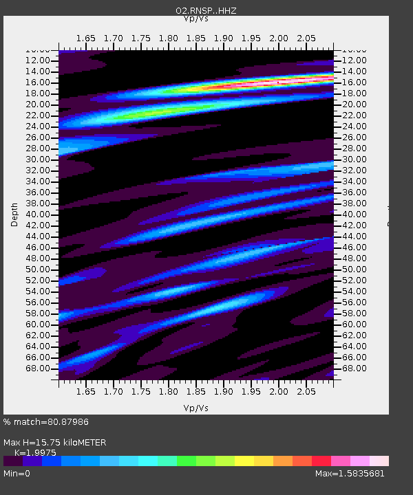
| Estimated Moho Depth: |
15.75 km |
| Estimated Crust Vp/Vs: |
2.00 |
| Assumed Crust Vp: |
6.315 km/s |
| Estimated Crust Vs: |
3.162 km/s |
| Estimated Crust Poisson's Ratio: |
0.33 |
|
| Radial Match: |
80.87986 % |
| Radial Bump: |
400 |
| Transverse Match: |
72.537796 % |
| Transverse Bump: |
400 |
| SOD ConfigId: |
31937991 |
| Insert Time: |
2023-10-30 12:27:55.819 +0000 |
| GWidth: |
2.5 |
| Max Bumps: |
400 |
| Tol: |
0.001 |
|

Signal To Noise
| Channel | StoN | STA | LTA |
| O2:RNSP: :HHZ:20231016T11:44:18.79497Z | 12.144008 | 4.681565E-6 | 3.855041E-7 |
| O2:RNSP: :HHN:20231016T11:44:18.79497Z | 4.838303 | 1.5204092E-6 | 3.1424432E-7 |
| O2:RNSP: :HHE:20231016T11:44:18.79497Z | 2.9392583 | 1.3840163E-6 | 4.7087264E-7 |
| Arrivals |
| Ps | 2.6 SECOND |
| PpPs | 7.2 SECOND |
| PsPs/PpSs | 9.8 SECOND |


