You are here: Home > Network List > O2 - Oklahoma Consolidated Temporary Seismic Networks Stations List
> Station SC16 Oakwood, Oklahoma, USA > Earthquake Result Viewer
SC16 Oakwood, Oklahoma, USA - Earthquake Result Viewer
| Earthquake location: |
Andreanof Islands, Aleutian Is. |
| Earthquake latitude/longitude: |
52.4/-176.9 |
| Earthquake time(UTC): |
2023/10/16 (289) 11:35:31 GMT |
| Earthquake Depth: |
187 km |
| Earthquake Magnitude: |
6.4 Mww |
| Earthquake Catalog/Contributor: |
NEIC PDE/us |
|
| Network: |
O2 Oklahoma Consolidated Temporary Seismic Networks |
| Station: |
SC16 Oakwood, Oklahoma, USA |
| Lat/Lon: |
35.97 N/98.82 W |
| Elevation: |
500 m |
|
| Distance: |
55.6 deg |
| Az: |
74.169 deg |
| Baz: |
313.448 deg |
| Ray Param: |
0.0640808 |
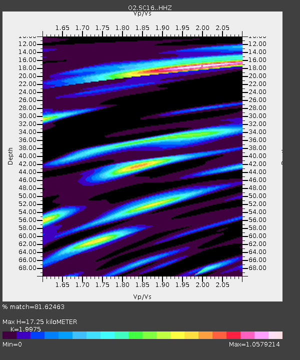
| Estimated Moho Depth: |
17.25 km |
| Estimated Crust Vp/Vs: |
2.00 |
| Assumed Crust Vp: |
6.315 km/s |
| Estimated Crust Vs: |
3.162 km/s |
| Estimated Crust Poisson's Ratio: |
0.33 |
|
| Radial Match: |
81.62463 % |
| Radial Bump: |
400 |
| Transverse Match: |
62.94641 % |
| Transverse Bump: |
400 |
| SOD ConfigId: |
31937991 |
| Insert Time: |
2023-10-30 12:28:18.719 +0000 |
| GWidth: |
2.5 |
| Max Bumps: |
400 |
| Tol: |
0.001 |
|

Signal To Noise
| Channel | StoN | STA | LTA |
| O2:SC16: :HHZ:20231016T11:44:16.960009Z | 14.2028475 | 4.3838722E-6 | 3.086615E-7 |
| O2:SC16: :HHN:20231016T11:44:16.960009Z | 4.1473675 | 1.7114544E-6 | 4.126604E-7 |
| O2:SC16: :HHE:20231016T11:44:16.960009Z | 4.4331813 | 1.4646176E-6 | 3.3037622E-7 |
| Arrivals |
| Ps | 2.8 SECOND |
| PpPs | 7.8 SECOND |
| PsPs/PpSs | 11 SECOND |


