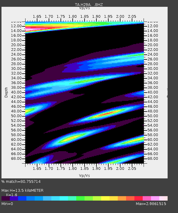
H29A Onida, SD, USA - Earthquake Result Viewer

Earthquake location: Fox Islands, Aleutian Islands
Earthquake latitude/longitude: 52.7/-169.4
Earthquake time(UTC): 2010/07/28 (209) 11:31:46 GMT
Earthquake Depth: 10 km
Earthquake Magnitude: 5.6 MW, 5.2 MS, 5.2 MB, 5.1 ML
Earthquake Catalog/Contributor: WHDF/NEIC
Network: TA USArray Transportable Network (new EarthScope stations)
Station: H29A Onida, SD, USA
Lat/Lon: 44.63 N/100.21 W
Elevation: 548 m
Distance: 44.8 deg
Az: 71.356 deg
Baz: 306.085 deg
Ray Param: 0.07170192
Estimated Moho Depth: 13.5 km
Estimated Crust Vp/Vs: 1.60
Assumed Crust Vp: 6.53 km/s
Estimated Crust Vs: 4.082 km/s
Estimated Crust Poisson's Ratio: 0.18
Radial Match: 80.755714 %
Radial Bump: 375
Transverse Match: 71.44738 %
Transverse Bump: 400
SOD ConfigId: 319893
Insert Time: 2011-01-05 13:45:26.357 +0000
GWidth: 2.5
Max Bumps: 400
Tol: 0.001

Signal To Noise

ChannelStoNSTALTA
TA:H29A: :BHZ:20100728T11:39:29.325011Z8.2234467.571729E-79.207489E-8
TA:H29A: :BHN:20100728T11:39:29.325011Z1.50152953.5513503E-72.3651553E-7
TA:H29A: :BHE:20100728T11:39:29.325011Z1.77441457.192365E-74.0533735E-7
Arrivals
Ps1.3 SECOND
PpPs5.0 SECOND
PsPs/PpSs6.3 SECOND