You are here: Home > Network List > OK - Oklahoma Seismic Network Stations List
> Station CROK Carrier, Oklahoma > Earthquake Result Viewer
CROK Carrier, Oklahoma - Earthquake Result Viewer
| Earthquake location: |
Andreanof Islands, Aleutian Is. |
| Earthquake latitude/longitude: |
52.4/-176.9 |
| Earthquake time(UTC): |
2023/10/16 (289) 11:35:31 GMT |
| Earthquake Depth: |
187 km |
| Earthquake Magnitude: |
6.4 Mww |
| Earthquake Catalog/Contributor: |
NEIC PDE/us |
|
| Network: |
OK Oklahoma Seismic Network |
| Station: |
CROK Carrier, Oklahoma |
| Lat/Lon: |
36.50 N/97.98 W |
| Elevation: |
403 m |
|
| Distance: |
55.7 deg |
| Az: |
73.144 deg |
| Baz: |
313.359 deg |
| Ray Param: |
0.064001255 |
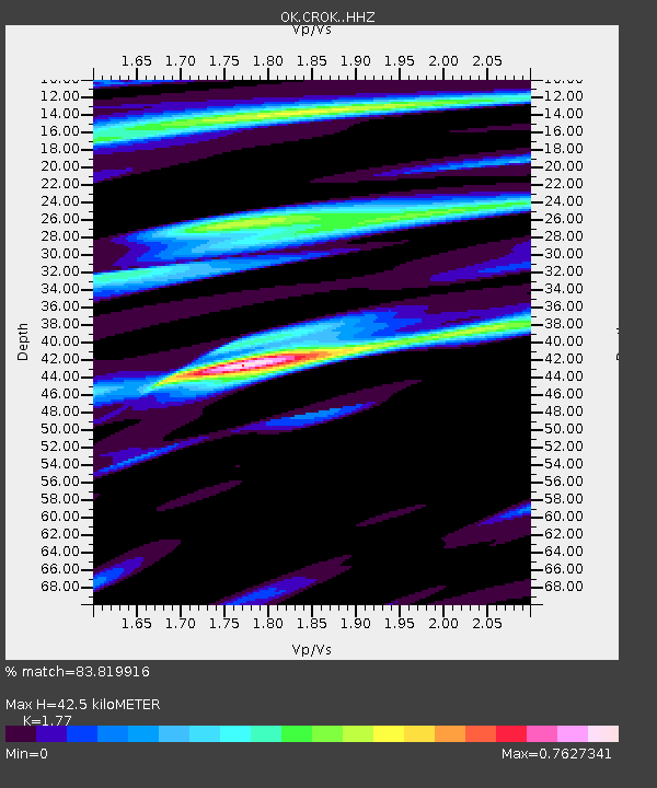
| Estimated Moho Depth: |
42.5 km |
| Estimated Crust Vp/Vs: |
1.77 |
| Assumed Crust Vp: |
6.483 km/s |
| Estimated Crust Vs: |
3.662 km/s |
| Estimated Crust Poisson's Ratio: |
0.27 |
|
| Radial Match: |
83.819916 % |
| Radial Bump: |
400 |
| Transverse Match: |
76.74349 % |
| Transverse Bump: |
400 |
| SOD ConfigId: |
31937991 |
| Insert Time: |
2023-10-30 12:29:03.622 +0000 |
| GWidth: |
2.5 |
| Max Bumps: |
400 |
| Tol: |
0.001 |
|

Signal To Noise
| Channel | StoN | STA | LTA |
| OK:CROK: :HHZ:20231016T11:44:17.850023Z | 18.851603 | 4.756474E-6 | 2.5231137E-7 |
| OK:CROK: :HHN:20231016T11:44:17.850023Z | 3.0973961 | 1.3690457E-6 | 4.4199894E-7 |
| OK:CROK: :HHE:20231016T11:44:17.850023Z | 4.547364 | 1.5754684E-6 | 3.4645748E-7 |
| Arrivals |
| Ps | 5.3 SECOND |
| PpPs | 17 SECOND |
| PsPs/PpSs | 23 SECOND |


