You are here: Home > Network List > PQ - Public Safety Geoscience Program Canadian Research Network (PSGP) Stations List
> Station ALBHB Albert Head, Victoria, BC, Canada > Earthquake Result Viewer
ALBHB Albert Head, Victoria, BC, Canada - Earthquake Result Viewer
| Earthquake location: |
Andreanof Islands, Aleutian Is. |
| Earthquake latitude/longitude: |
52.4/-176.9 |
| Earthquake time(UTC): |
2023/10/16 (289) 11:35:31 GMT |
| Earthquake Depth: |
187 km |
| Earthquake Magnitude: |
6.4 Mww |
| Earthquake Catalog/Contributor: |
NEIC PDE/us |
|
| Network: |
PQ Public Safety Geoscience Program Canadian Research Network (PSGP) |
| Station: |
ALBHB Albert Head, Victoria, BC, Canada |
| Lat/Lon: |
48.39 N/123.49 W |
| Elevation: |
40 m |
|
| Distance: |
33.6 deg |
| Az: |
75.156 deg |
| Baz: |
297.418 deg |
| Ray Param: |
0.07752299 |
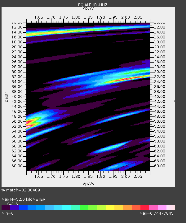
| Estimated Moho Depth: |
52.0 km |
| Estimated Crust Vp/Vs: |
1.60 |
| Assumed Crust Vp: |
6.566 km/s |
| Estimated Crust Vs: |
4.104 km/s |
| Estimated Crust Poisson's Ratio: |
0.18 |
|
| Radial Match: |
82.00409 % |
| Radial Bump: |
400 |
| Transverse Match: |
61.845444 % |
| Transverse Bump: |
400 |
| SOD ConfigId: |
31937991 |
| Insert Time: |
2023-10-30 12:30:41.191 +0000 |
| GWidth: |
2.5 |
| Max Bumps: |
400 |
| Tol: |
0.001 |
|

Signal To Noise
| Channel | StoN | STA | LTA |
| PQ:ALBHB: :HHZ:20231016T11:41:23.759997Z | 11.4051695 | 5.497493E-6 | 4.8201764E-7 |
| PQ:ALBHB: :HHN:20231016T11:41:23.759997Z | 4.654097 | 1.2988768E-6 | 2.7908246E-7 |
| PQ:ALBHB: :HHE:20231016T11:41:23.759997Z | 12.555419 | 3.8451467E-6 | 3.0625395E-7 |
| Arrivals |
| Ps | 5.2 SECOND |
| PpPs | 19 SECOND |
| PsPs/PpSs | 24 SECOND |


